Just where was Pepper Alley?
I have been sent this remarkable and incredibly thorough piece of research into the historical and mapping record for Pepper Alley by Hilary Little. Hilary, you’ll remember, was the driving force behind the project to record the history and fabric of the lost beer house, the Royal Oak, in Bullings Heath, Waslall Wood.
Here, Hilary adds a huge amount to the ongoing debate about the location of the mysterious Pepper Alley, which has puzzled local historians for many years. Everyone seems to have their own opinion as to where this long-gone thoroughfare existed, and as to exactly what the the name referred.
This article leads on from Hilary’s previous work on the subject, and also from David Evans surprising revelations about the involvement of the Street Family in the same area, which I posted last week.
I thank Hilary for a fantastic and very high quality piece of research, which I am proud and honoured to be able to post for readers. This is what local history is about – people looking at the place they love, and exploring the collective record together.
Hilary wrote:
Location of Pepper Alley – My Thoughts
This evidence is taken from four documents and the maps held within them and a couple of others from the blog.
The document I cite include:
- The Indenture which details the sale of a parcel of land to Joseph Wright in 1857
- The extract from the Inclosure award 1875
- The Abstract of the Title of Mr. Noah Cresswell to the Royal Oak Inn Walsall Wood, 1905 (he was the husband of Joseph’s daughter Emma). This was prepared as far as I can tell for the sale of the Inn to Lichfield Brewery
- The Abstract of the Title of Mrs. M A Smith to freehold property at Green Lane Walsall Wood in the County of Staff 1948 she was Joseph’s other daughter, Mary Ann and was married to Daniel. She had inherited the land from him upon his death and this abstract was prepared, when Mary Ann’s representatives sold no 4 and no 6 Green Lane to the council upon her death.
Both of these later documents tell the story of the splitting in two of the land owned by Joseph Wright in 1893 as it passes on to Noah and Daniel.

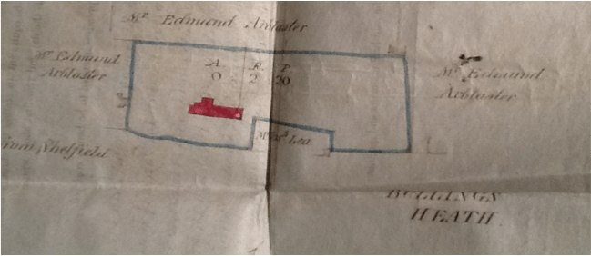
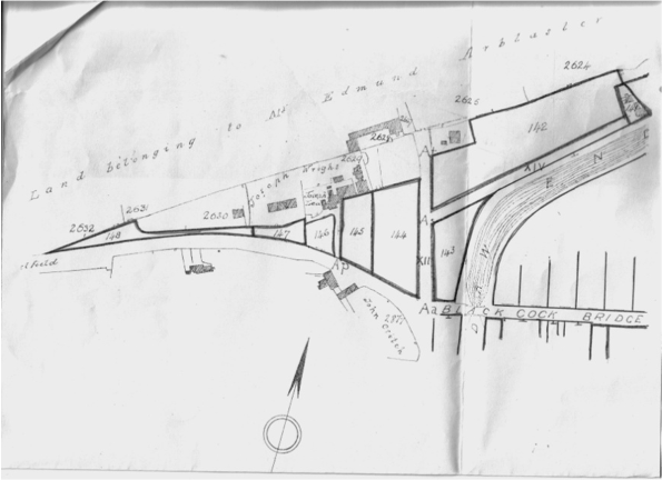
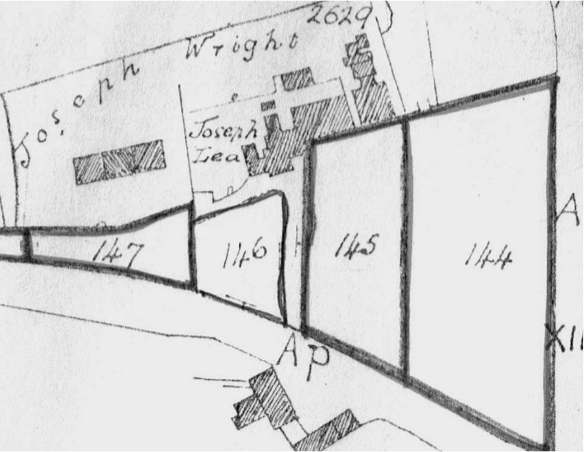
From the document of sale to Joseph Wright, 1857. Image kindly supplied by Hilary Little.
This is the plan taken from the document of Sale to Joseph Wright in 1857. The indenture says that Joseph Wright bought land and 3 cottages ‘adjoining each other with the yards, gardens and outbuildings thereto adjoining and belonging situate at Walsall Wood’ then in the occupation of ‘John Chamberlain, Joseph Thomas and Michael England.’ This would seem to be the buildings here in red.
A chunk of land owned by Joseph Lea is shown cutting into this area but the surrounding land is owned by Edmund Arblaster. The area is called Bullings Heath. There is no indication of what other houses exist here so do we have any map evidence from the wider area for this time?

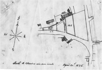
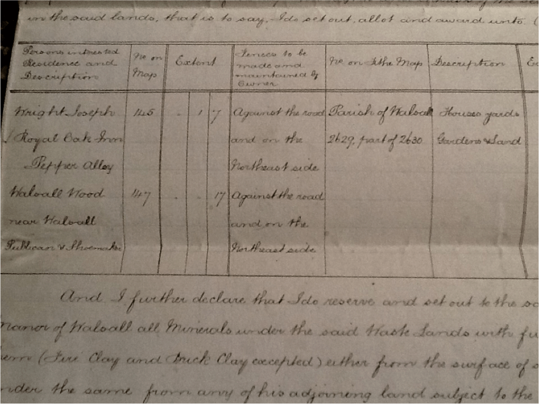
1875 plan. Image kindly supplied by Hilary Little.
This plan from 1875 outlines the two parcels of land awarded to Joseph Wright as detailed in an extract of Inclosure award… where Joseph Wright’s address is actually given as Pepper Alley.
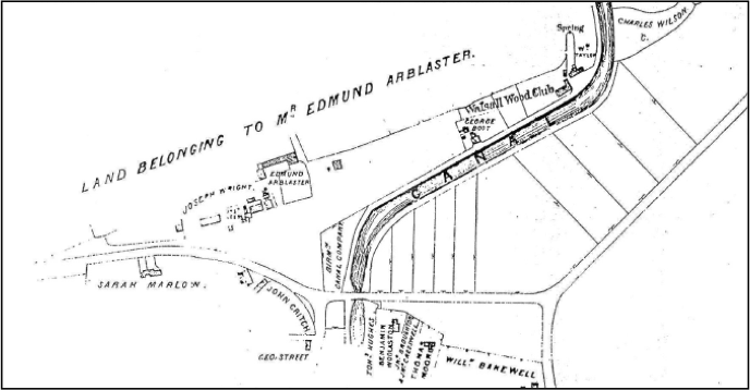
Caz’s map shows more detail of the surrounding area:

Image kindly supplied by reader Caz.
This again dates from the same time frame and appears to refer to the same inclosure award.

Inclossure awar map detail, as supplied by reader [Howmuch?].
Above is an extract from a map sent to the blog by Howmuch for the Inclosure award and dated 1876, so just a year later than above.
This shows the land owned by Edmund Arblaster, Joseph Wright, John Critch, George Street, Sarah Marlow and George Boot up by the canal. Evidence of Joseph Lea’s land is not apparent here but you can see the buildings and evidence exists before and after this map.

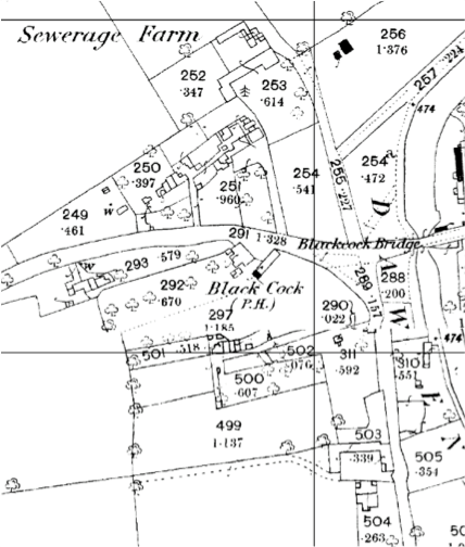
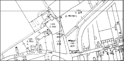
1888 Ordnance 1:2,500 Survey map of the area.
This map shows the area around Hall Lane in 1888, after George Street’s house. From David’s evidence we can put George Twist in the house owned by George Street and in 1871 he appears on the census as the last house in Bullings Heath before Hall Lane.
These maps show a number of access ways…
- The main road which appears to veer round into Hall Lane as well as going up and over the bridge. There is no evidence as to what this road was called although we now know it as Green Lane.
- A route to to Arblaster’s farm which forks out to the property owned by George Boot alongside the canal.
- A further route serving the old cottages from 1857, and a growing community of newer houses with the new Royal Oak, its next door neighbours and also, a house marked as being Joseph Lea’s house on the other side (which may have been there in 1857… We don’t know yet).
- A route next to the house owned by George Street which looks like it goes down to some cottages behind the Black Cock.
Can anyone suggest any others? If not then, as we have references to several homes in this area as being in Pepper Alley/Lane is it safe to say that this address must exist somewhere in this small area?
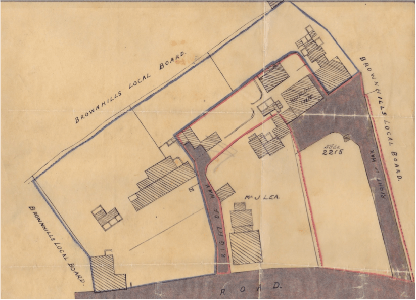
To get a bit more information about Joseph Lea’s whereabouts, lets leap forward a little to 1893. The plan below shows more clearly what land belonged to Joseph Wright and what belonged to Joseph Lea at this time.
(Incidentally, the plan was drawn up to mark the entitlements of Joseph’s Wright’s two sons in law, Noah Cresswell and Daniel Smith when the land was split up in 1893.)
Joseph Wright owned all the land outlined above except for the bit in the middle which was owned by Joseph Lea. We know that some of this land was owned by Lea back in 1857 although the extent of it and what was built on it is not recorded on the map of that time.

Wright’s 1893 plan marking the entitlements of his sons-in-law. Image supplied by Hilary Little.
Now another question – what was the purpose to the inclosure act and how did it affect the land ownership of the area? We know that Joseph Wright was awarded parcels of land identified as 145 and 147 on the Extract of inclosure award.
Does it makes sense, to suggest that Lea’s land would have grown in the same way as Wright’s by obtaining land parcel number 146 in the Inclosure award? If so, both of these landowners now own land that fronts on to the road we know as Green Lane.
While this map shows a house built on to Green Lane labelled Mr. J. Lea, we know he lived here before this house was built as he appears on the 1871 census. If we look at both Caz’s map and the above map, there is a collection of buildings (ringed in the plan above) which, although they look joined to the Royal Oak, they are clearly not built on land owned by Joseph Wright. I suspect that this was where Lea lived in 1871.

Extract from plan supplied by reader Caz.
So, going back to Caz’s map of 1875 you have a little community all set back off the road, separated from the road (Green Lane) by common land down a little path way.
Remember at this time Joseph Wrights address is given as ‘Royal Oak Inn, Pepper Alley’.
Does this evidence point to Pepper Alley being the lane down which all these houses were accessed?
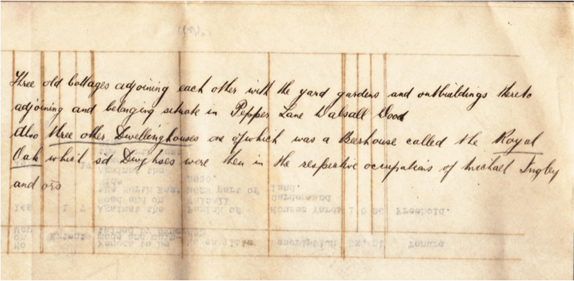
As further evidence, there is a reference to Pepper Lane (rather than Alley) which records an agreement between Joseph Wright and H. Highway (it is unclear whether this dates from 1860 or 1875, but it appears in the abstract of Title for Noah Cresswell. I think this reference refers to the whole plot of land owned by Joseph Wright at that time and describes it thus:
’Three old cottages adjoining each other with the yard, gardens and outbuildings adjoining and belonging situate in Pepper Lane Walsall Wood.
‘Also three other dwelling houses one of which was a beerhouse called the Royal Oak which said dwelling houses were then in the respective occupations of Michael Ingby? and others.’
(At least I think that’s what it says – can anyone clarify that?)

Agreement between Joseph Wright and H. Highway, date unclear. Image supplied by Hilary Little.
The three old cottages mentioned here would seem to be the ones that were in existence in all the above maps from 1857 up to 1893, the pub and the house next door to the Royal Oak we know was ‘semi-detached’, so that description fits with the map evidence.
In 1893, when the land is shared between the two sons-in-law, the land outlined in blue (which became Daniel Smith’s land) on the above plan dated 1893, a funny kind of C-shaped plot, contained these cottages and (according to the abstract of title of Mrs. Mary Ann Smith), was described thus:
‘Land conting 3075 sq yds… Six messuages or tenements… One of which fronts to sd road and in the occpn of Francis Ball… Three other houses stand back on said land and in the respective occupations of Matthew Cresswell, Wm Pincher and James Parker’
That was, I think, the three old cottages. Further:
‘…And the other two of the said houses were near to a beerhouse called the Royal Oak Inn and were in the respective occupations of James Harries and William Amos’
Probably the semis that later became known as no 4 and no 6 Green Lane?
Again the description fits with the map evidence, and pretty much pinpoints where these people from the 1891 census lived – of course lodgers, sub letters etc. I can’t account for.
Curiously also by 1893, new access arrangements have been created in that there are now two rights of way serving the properties, neither of them in quite the same place as the original access way. I do believe this is still marked on the 1893 map as it represents the border between land that became Noah Cresswells (marked in red), and Joseph Lea’s land.
[Bob’s note: This is true, they do appear to move a little. I was confounded by this movement when overlaying mapping onto Google Earth a couple of years ago, and dismissed it as a drafting error. I clearly wasn’t.]
After 1893, yet more houses were built on land formerly owned by Joseph Wright including those which fronted on to Green Lane as shown in the 1938 map.

1938 Ordnance Survey 1:2,500 map of Ppper Alley and Bullings Heath.
Interestingly, in the newer conveyance documents for the old pub – that is, the one recording its sale to George Powell by Lichfield Brewery in 1936 – it talks about ‘the road leading from Walsall to Brownhills now known as Green Lane, Walsall Wood, ’ which rather suggests that this road was previously not known as Green Lane at this point on its route.
What about the evidence for the route way in Hall Lane itself being Pepper Alley? Well notwithstanding the fact that this would mean that the Extract from the Inclosure Act giving the address of Joseph Wright was wrong, what evidence exists? Are there enough houses here to explain the number of references that exist for Pepper Alley?
A lot of conjecture here but is it possible that what started off as Pepper Alley, grew to encompass the whole area, including perhaps the area just in Hall Lane. Maybe that meant that it needed to take on a more fitting name and thus it became known to some as Pepper Lane?
Like this:
Like Loading...


 RSS - Posts