


 #365daysofbiking Journal
Recent tracks

 The MagicianAlmunia13 minutes ago
Follow what you areAlmunia20 minutes ago
Views From A Blue TrainAlmunia26 minutes ago
Ode To MomAlmunia33 minutes ago
Wrapped In Your HairAlmunia38 minutes ago
The AwakeningAlmunia44 minutes ago
The MagicianAlmunia13 minutes ago
Follow what you areAlmunia20 minutes ago
Views From A Blue TrainAlmunia26 minutes ago
Ode To MomAlmunia33 minutes ago
Wrapped In Your HairAlmunia38 minutes ago
The AwakeningAlmunia44 minutes ago Far ClosesCraven Faults15 hours ago
Drover Hole SikeCraven Faults15 hours ago
Incline HuttesCraven Faults15 hours ago
Up Goods Distant, Down Goods HomeCraven Faults15 hours ago
Far ClosesCraven Faults15 hours ago
Drover Hole SikeCraven Faults15 hours ago
Incline HuttesCraven Faults15 hours ago
Up Goods Distant, Down Goods HomeCraven Faults15 hours agoRecent Comments
chrisjimallen on Down the tubes bravelyd03ee3c14f on Celebrating a Jubilee? bravelyd03ee3c14f on Celebrating a Jubilee? Nathan on Raising damp Steve Myatt on Off their trolleys
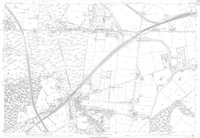
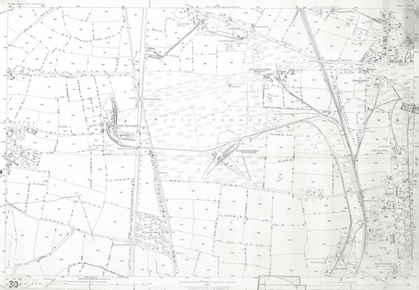
Tag Archives: Ordnance Survey
The Metz office?
An intriguing enquiry reaches me from local historian and blog dynamo the young David Evans, who’s after a rather specific bit of history relating to a lost courtyard of dwellings in Brownhills High Street Called ‘The Metz’.
Posted in Bad Science, Brownhills stuff, Environment, Followups, Fun stuff to see and do, Interesting photos, It makes me mad!, Just plain daft, Local History, Local media, Local politics, News, planning, Reader enquiries, Shared media, Shared memories, Social Media
Tagged 1883, 1:2500, bad housing, Brownhills, Brownhills local history, Brownhills Urban District Council, clearance, David Evans, Dr. Bradford, George Bradford, Hill sisters, Lichfield Mercury, Local History, Metz, Norman Waine, Ogley Hay, Ogley Square, Old maps, Ordnance Survey, Peter Cutler, Richard Burnell, Slum clearance, snaitationG, Staffordshire, Things to do, UDC, Urban District Council
4 Comments
If the cap fits…
On Sunday I rode up Coppice Lane in Brownhills for the first time in a few weeks, and noticed that contractors for The Coal Authority – the body charged with monitoring and remediating historic mineworkings – had been hard at work capping the two shafts left over from the West Coppice Colliery, near the old level Crossing.
Posted in Brownhills stuff, Chasewater, Environment, Followups, Fun stuff to see and do, Interesting photos, Local History, Local media, News, Reader enquiries, Shared media, Shared memories, Social Media, Spotted whilst browsing the web, Walsall community
Tagged Brownhills, Brownhills common, Brownhills local history, Brownhills Past, Brownhlls coal mines, Bug row, Capped, Cathedral Pit, Chasewater, Coal Authority, Coppice Colliery CO., Coppice Cottages, Coppice Pit, David Fellows, Derelict, Engine, Engine Lane, local blogs, Local History, Marklew, Marklew's Pond, mining in brownhills, New Photos, Norton Pool, Old maps, Ordnance Survey, Pump, Reservoir, Robert Webster, Staffordshire, Steam pump, West Colliery, William Harrison
4 Comments
Lose yourself in the mapping
If you’re engaged in the local online community, you’ll have no doubt caught up with this already, but for those who haven’t, there’s a new historical mapping resource available online right now, free of charge, and it’s really rather special. Continue reading
Posted in Bad Science, Brownhills stuff, Clayhanger stuff, Environment, Followups, Fun stuff to see and do, Local History, Local media, News, Reader enquiries, Shared media, Shared memories, Walsall Wood stuff
Tagged 10000, 1250, 2500, Brownhills, Brownhills local history, cartography, Clayhanger, David Evans, guide, how to read, key abbreviations, Large Scale, Lichfield, Local History, Mapping, Old maps, Ordnance Survey, sheet, Silly, street plan, symbol, Things to do, Walsall Wood
7 Comments
Following the map – those abbreviations in full
One of the good things about Christmas is having time to catch up with the posts I’ve been meaning to compile for ages – this one is a specific one that’s been needed since I started the blog really, and is a key to very large scale maps I use here on the blog.

Continue reading
Posted in Bad Science, Brownhills stuff, Clayhanger stuff, Environment, Followups, Fun stuff to see and do, Local History, Local media, News, Reader enquiries, Shared media, Shared memories, Walsall Wood stuff
Tagged 10000, 1250, 2500, Brownhills, Brownhills local history, cartography, Clayhanger, David Evans, guide, how to read, key abbreviations, Large Scale, Lichfield, Local History, Mapping, Old maps, Ordnance Survey, sheet, Silly, street plan, symbol, Things to do, Walsall Wood
3 Comments
Challenging landscapes
Today, I’ve mostly been trawling the paper mapping record for Clayhanger, in order to throw a little more light on the issues it faced in the post war years – debate about subsidence and flooding and the subsequent land restoration that occurred has been ongoing, and this is a really interesting bit of local history for me.
Posted in Brownhills stuff, Clayhanger stuff, Environment, Followups, Fun stuff to see and do, Local History, Local media, News, Shared media, Shared memories, Walsall Council, Wildlife
Tagged Clayhanger, Clayhanger Common, Culverts, Derelict, Drain, Drainage, flooding, Ford Brook, Local History, Marsh, New Photos, Ordnance Survey, pit, Pump, pump house, Railway, Shire Oak, spoil, Spot Lane, Staffordshire, stormwater, Subsidence, The Spot, The Spot pumping station, Walsall Wood Colliery
6 Comments
A little to the east
Following on from the post ‘Old ground’, reader Mike Armstrong asked for more of the Lichfield and Whittington area – so here you go.
Posted in Brownhills stuff, Cannock Chase, Chasewater, Clayhanger stuff, Followups, Fun stuff to see and do, Local History, Local media, News, Reader enquiries, Shared media, Walsall Wood stuff
Tagged Brownhills local history, Canal, first edition, Hopwas, Lichfield, Local History, Mike Armstrong, Old maps, Ordnance Survey, Redevelopment, Staffordshire, Trent BValley, WHittington
12 Comments
Old Ground
Here’s some mapping I’ve been meaning to run since reader Peter mentioned it in the comments to the post ‘Keep out of Cotterill’s road’ on Friday last – I may have posted similar before, but if I have, I can’t find a copy.
 Continue reading
Posted in Brownhills stuff, Cannock Chase, Chasewater, Clayhanger stuff, Followups, Fun stuff to see and do, Local History, Local media, News, Reader enquiries, Shared media, Walsall Wood stuff
Tagged 1838, Aldridge, Brownhills, Brownhills local history, Canal, Chasewater, Clayhanger, first edition, Gerald Reece, Inclosure, Lichfield, Local History, Old maps, Ordnance Survey, Peter, Redevelopment, Shire Oak, Staffordshire, Stonnall, The Machine House, Tonnage House, Walsall, Walsall Wood
24 Comments
An unearned income
It is with great pleasure that I can now continue the story of the slum clearance of Ogley Square in 1935, thanks to the efforts of an anonymous reader and top friend of the blog Richard Burnell.
Posted in Bad Science, Brownhills stuff, Environment, Followups, Fun stuff to see and do, Interesting photos, It makes me mad!, Just plain daft, Local History, Local media, Local politics, News, planning, Reader enquiries, Shared media, Shared memories, Social Media
Tagged 1883, 1:2500, bad housing, Brownhills, Brownhills local history, Brownhills Urban District Council, clearance, Dr. Bradford, George Bradford, Hill sisters, Lichfield Mercury, Local History, Norman Waine, Ogley Hay, Ogley Square, Old maps, Ordnance Survey, Peter Cutler, Richard Burnell, Slum clearance, snaitationG, Staffordshire, Things to do, UDC, Urban District Council
6 Comments
Supporting services
It’s been a while since I did a mapping post here on the blog, and yesterday, whilst visiting the open day at Christchurch, in Leomonsley, I saw a huge copy of the 1884 OS map of Lichfield that inspired me. If you ever get chance to see it, do so. A beautiful, A0-size hand-tinted copy, clearly for ecclesiastical use. A thing of rare and immense beauty.
 Continue reading
Posted in Churches, cycling, Environment, Followups, Fun stuff to see and do, Just plain daft, Local Blogs, Local History, Local media, News, Shared media, Shared memories, Social Media
Tagged 1884, 1902, 1928, 1965, Bison, Canal, Chappells, Christchurch, Cross City, Cycle rides, Dovehousfield, Events, Leamonsley, Lichfield, Lichfield Lore, local blogs, Local History, Old maps, Ordnance Survey, Sandfields, Silly, Sloppy Wood, South Staffordshire, south staffordshire water, Staffordshire, Things to do
17 Comments
Seeing the Wood for the trees
Continuing the paper maps, here’s an 1884 12,500 scale Ordnance Survey map of southern Walsall Wood.
 Continue reading
Posted in Brownhills stuff, Churches, Environment, Followups, Fun stuff to see and do, Local History, Local media, News, Reader enquiries, Shared media, Walsall community, Walsall Wood stuff
Tagged 1884, 1:2500, Brownhills, Brownhills local history, Druids Heath, Local History, Old maps, Ordnance Survey, Staffordshire, Things to do, Walsall Wood
8 Comments
Gorgeous curves
Here’s a bit of a request stop. A few weeks ago there was a very positive response to my digitally contouring of an Ordnance Survey map in the analysis of the Watford Gap area near Sutton Coldfield.
I have a bit of clever software that can do this, and access to the mapping data to use as a canvas.
 Continue reading
Posted in Brownhills stuff, Cannock Chase, Chasewater, Environment, Followups, Fun stuff to see and do, Interesting photos, Local media, News, Reader enquiries, Shared media, Social Media, Walsall community, Walsall Wood stuff
Tagged Barr Beacon, Brownhills, Cannock Chase, Chasewater, Contour, Lichfield, Mapping, maps, Ordnance Survey, Relief, Reservoir, Shire Oak, Staffordshire, Stonnall, Things to do, Topografic, Walsall, Walsall Wood
5 Comments
Squared
Just a quicky. Here’s an 1883 Ordnance Survey map of the northern half of Brownhills. I dug it out particularly for the lady – Vicki Brosch – who recently asked where Ogley Square was. It can be seen approximately a third of the way across the map from the right, just up from the bottom.
Posted in Brownhills stuff, Churches, Environment, Followups, Local History, Local media, News, Reader enquiries, Shared media, Walsall community
Tagged 1883, 1:2500, Brownhills, Brownhills local history, Local History, Ogley Hay, Ogley Square, Old maps, Ordnance Survey, Pike Helve, Pike Hill, Staffordshire, Things to do, Vicki Brosh
6 Comments
After the gold rush
I thought that today, I’d dig some interesting mapping out of the archive. In the light of Gerald Reece’s talk on Brownhills and it’s colliery history, I thought this 1884 1:2,500 scale plan of Wyrley Common was due an outing. It shows – in some clarity – the extent of mining in the Engine Lane area at the height of the Victorian period.
 Continue reading
Posted in Brownhills stuff, Environment, Followups, Local History, News, Shared media, Walsall community
Tagged 1884, 1:2500, Brownhills, Brownhills Colliey, Brownhills local history, Canal, Cathedral Pit, Engine Lane, Gerald Reece, Grove Colliery, Local History, Old maps, Ordnance Survey, Palmers Hay, Staffordshire, Wyrley common
8 Comments
Home on The Grange
Thanks to reader contributions, we’ve found the Grange in Aldridge – it was, until relatively recently, in Leighswood, as described by commentors to my original post. Hat tip too, to David Evans, who mailed me with a map which jogged my memory.
 Continue reading
Posted in Environment, Followups, Fun stuff to see and do, Local Blogs, Local History, Local media, News, Reader enquiries, Shared media, Shared memories, Social Media, Spotted whilst browsing the web, Walsall community, Walsall Wood stuff
Tagged 1887, 1903, 1920, 1956, 1961, 1971, Aldridge, Birmingham History Forum, David Evans, Lazy Hill, Leighswood, Local History, Mary Woodroffe, New Photos, Northgate, Old maps, Ordnance Survey, Pennard, Redevelopment, Staffordshire, The Grange, Things to do, Walsall Wood, Walsall Wood Road, Walton Road
13 Comments
Wood work
This is a post for top reader, contributor and friend of the blog David Evans. A couple of days ago, he emailed me asking if I had any old maps covering the general Walsall Wood area. Well, it took me … Continue reading
Posted in Brownhills stuff, Environment, Followups, Interesting photos, Local History, Local media, News, Reader enquiries, Shared media, Shared memories, Social Media, Walsall community, Walsall Wood stuff
Tagged 1884, 1902, 1919, 1938, 1:2500, aerial imagery, Aerofilms, Brownhills, Brownhills local history, David Evans, Local History, New Photos, Old maps, Ordnance Survey, Redevelopment, Staffordshire, Walsall Wood
2 Comments
Stretching things a bit…
Long-time reader reader and friend of the blog Bev Lloyd pointed out via Facebook that she liked the topographic thing I occasionally do with maps, where I pull them into 3D representations of the contours they cover. I do this … Continue reading
Posted in Brownhills stuff, Cannock Chase, Chasewater, Environment, Features, Followups, Fun stuff to see and do, Local History, Local media, Reader enquiries, Shared media, Social Media, Walsall community
Tagged 3d, Bev Lloyd, Brownhills, Brownhills local history, Chasewater, Facebook, geography, Local History, Old maps, Ordnance Survey, OS, Shire Oak, Silly, Staffordshire, Stonnall, Topographic maps, Walsall Wood
2 Comments
The Drifters
Right, I thought, let’s do it. Following the recent attention to the Anglesey Wharf and coal screening conveyor, I considered that it must be possible to find the Anglesey Basin drift shaft within the mapping record. Someone will have plotted … Continue reading
Posted in Brownhills stuff, Chasewater, Environment, Followups, Fun stuff to see and do, Interesting photos, Local History, Local media, News, Reader enquiries, Shared media, Shared memories, Social Media, Spotted whilst browsing the web, Walsall community
Tagged Adit, Anglesey Wharf, Brownhills, Brownhills local history, Brownhills Past, Canal, Chasewater, Chasewater Dam, Coal Mining, Conveyor, Cycle rides, Derelict, drift shaft, Local History, Narrowboats, Old maps, Ordnance Survey, Redevelopment, Reservoir, Staffordshire, Wildlife
7 Comments
On the conveyor?
I picked up a really good map recently. It’s a 1:2,500 plot of eastern Chasewater, the Anglesey Basin and Wharf, and the area of south Chasetown and The Triangle. It’s from 1962, and has a tad more information on it … Continue reading
Posted in Brownhills stuff, Chasewater, cycling, Environment, Followups, Fun stuff to see and do, Interesting photos, Local History, News, Shared media, Shared memories, Spotted whilst browsing the web, Wildlife
Tagged Anglesey Wharf, Brownhills, Brownhills local history, Brownhills Past, Canal, Chasewater, Chasewater Dam, Coal Mining, Conveyor, Cycle rides, Derelict, Local History, Narrowboats, Old maps, Ordnance Survey, Redevelopment, Reservoir, Staffordshire, Wildlife
10 Comments
Aldridge north west, 1884 and 1914
Following on from the 1884 Brownhills South and Walsall Wood map and others posted recently, I’ve dived into the digital archive after a request by reader Mike Hawes and pulled out the 1:2,500 scale gems from 1884 and 1914. They show … Continue reading
Posted in Environment, Features, Followups, Fun stuff to see and do, Local History, Local media, Reader enquiries, Shared media, Shared memories, Social Media, Walsall community, Walsall Wood stuff
Tagged 1884, 1914, 1:2500, Aldridge, Brownhills, Canal, David Evans, Dumblederry, Leighs Wood, Local History, map, Mike Hawes, mining, Old maps, Ordnance Survey, OS Map, scanned maps, Staffordshire
4 Comments
A cartographic history
In my recent post ‘Other people’s maps’, I featured an excerpt from a secondhand 1951 issue 1:25,000 scale map I’d acquired from a map dealer. The map – with Brownhills at its heart – carried some rather unusual hand written … Continue reading
Posted in Bad Science, Brownhills stuff, Chasewater, Clayhanger stuff, cycling, Environment, Followups, Fun stuff to see and do, Local History, Local media, News, planning, Reader enquiries, Shared media, Shared memories
Tagged Aldridge, Andy Dennis, Brownhills, Brownhills local history, Canal, Chasewater, Clayhanger, Coal measures, cycling, first edition, Geology, Local History, map, Mark T, Old maps, Ordnance Survey, OS, pathfinder, Rushall, second edition, Shelfield, Shire Oak, SK00, sk0010, SK43/00, Staffordshire, Stonnall, Walsall Wood
11 Comments
Other people’s maps
I’ve had a find I’m rather excited about, and I think I’m going to need reader help here. Over the weekend, I acquired a couple of maps from a dealer who puts to one side anything he knows I might … Continue reading
Posted in Bad Science, Brownhills stuff, Chasewater, Clayhanger stuff, Environment, Followups, Fun stuff to see and do, Local History, Local media, News, Shared media, Shared memories, Walsall Wood stuff
Tagged Brownhills, Brownhills local history, Canal, Chasewater, Clayhanger, Coal measures, Geology, Local History, Old maps, Ordnance Survey, Shire Oak, SK00, SK43/00, Staffordshire, Stonnall, Walsall Wood
6 Comments
The second coming
After the last post in which I made available the 1969 Ordnance Survey first series SK00 map of Brownhills, I can now present the map that replaced it. The first edition of the second edition (confused? You should be…) was … Continue reading
Posted in Brownhills stuff, cycling, Environment, Followups, Local History, Local media, News, planning, Shared media, Shared memories
Tagged Aldridge, Brownhills, Brownhills local history, Canal, Chasewater, cycling, first edition, Local History, map, Old maps, Ordnance Survey, OS, pathfinder, Rushall, second edition, Shelfield, SK00, sk0010, Staffordshire
Leave a comment
The last of a generation
As promised last weekend, thanks to the diligence of reader and co-conspirator [Howmuch?], I can now make available full scans of the 1969 issue Ordnance Survey sheet SK00, covering Brownhills and north Aldridge. This is a 1:25,000 map, based largely … Continue reading
Posted in Brownhills stuff, cycling, Environment, Followups, Local History, Local media, News, planning, Shared media, Shared memories
Tagged Aldridge, Brownhills, Brownhills local history, Canal, Chasewater, cycling, first edition, Local History, map, Old maps, Ordnance Survey, OS, Rushall, Shelfield, SK00, Staffordshire
7 Comments
Time passages
Now, here’s a thing. This is a teaser – I’ve got more maps. I have managed to get hold of Ordnance Survey 1:25,000 sheets covering Brownhills, just seven years apart in issue date, but there’s light years between them in … Continue reading
Posted in Brownhills stuff, Chasewater, Churches, Clayhanger stuff, Environment, Followups, Fun stuff to see and do, Local History, Local media, News, Shared media, Shared memories, Walsall Wood stuff
Tagged 1:25000, Brownhills, Brownhills local history, Canal, cartography, Chasewater, first edition, footpaths, Local History, maps, Old maps, Ordnance Survey, pathfinder, Politics, Redevelopment, second edition, SK00, SK10, Staffordshire, Walsall Wood
6 Comments
Hunt the toll…
Reader and prolific comment monger David Evans recently commented about toll gates marked on old mapping, so I thought I’d go back as far as I could and see what I could find. There are a good few marked on … Continue reading
Posted in Brownhills stuff, Clayhanger stuff, Environment, Features, Followups, Local History, Local media, Reader enquiries, Shared media, Social Media, Spotted whilst browsing the web, Walsall community, Walsall Wood stuff
Tagged 1800's, 1850, Brownhills, Brownhills common, Brownhills local history, Brownhills Past, Clayhanger, Local History, map, mining in brownhills, Old maps, Ordnance Survey, Shire Oak, Staffordshire
9 Comments
Mine, all mine…
Continuing the trawling of material relating to mining on Brownhills Common and the origins of Engine Lane, I happened upon a collection of survey plans in the excellent book ‘Coal Mining in Walsall Wood, Brownhills and Aldridge’ by Brian Rollins … Continue reading
Posted in Brownhills stuff, Chasewater, Environment, Followups, Fun stuff to see and do, Interesting photos, Local Blogs, Local History, Local media, Reader enquiries, Shared media, Shared memories, Social Media, Spotted whilst browsing the web, Walsall community
Tagged Brookes R Smith, Brownhills, Brownhills common, Brownhills local history, Brownhills Past, Brownhlls coal mines, Cathedral Pit, Chasewater, Coppice Colliery CO., Coppice Pit, David Fellows, Derelict, Engine, Engine Lane, local blogs, Local History, mining in brownhills, New Photos, Old maps, Ordnance Survey, Pump, Reservoir, Staffordshire, Steam pump, West Colliery, William Harrison
23 Comments
A hole in the history
If ever anything were to prove the importance of a detailed mapping record, than my post of Wednesday last, ‘Common ground’ does just that. Whilst dredging the available mapping for the area beforehand, the 1938 draftings were unavailable in the … Continue reading
Posted in Brownhills stuff, Chasewater, Environment, Followups, Fun stuff to see and do, Interesting photos, Local History, Local media, Reader enquiries, Shared media, Shared memories, Social Media, Spotted whilst browsing the web, Walsall community
Tagged Brownhills, Brownhills common, Brownhills local history, Brownhills Past, Brownhlls coal mines, Bug row, Cathedral Pit, Chasewater, Coppice Colliery CO., Coppice Cottages, Coppice Pit, David Fellows, Derelict, Engine, Engine Lane, local blogs, Local History, Marklew, Marklew's Pond, mining in brownhills, New Photos, Norton Pool, Old maps, Ordnance Survey, Pump, Reservoir, Robert Webster, Staffordshire, Steam pump, West Colliery, William Harrison
38 Comments
Back to the future…
While we’re in a 1980’s mood, this week I noticed that a remarkable project from the period had been rescued from potential oblivion and saved for the nation. Way back in 1986, when I was generally being a teenage geek … Continue reading
Posted in Brownhills stuff, Clayhanger stuff, Environment, Followups, Fun stuff to see and do, Interesting photos, Local History, Local media, Reader enquiries, Shared media, Shared memories, Social Media, Spotted whilst browsing the web, Walsall community, Walsall Council, Walsall Wood stuff
Tagged AIV, BBC Micro, Belbury, Brownhills, Brownhills Carnival, Brownhills local history, Brownhills Market, Canal, Clayhanger, Computek 87, Domesday, Domesday disc, Domesday project, Domesday Project reloaded, Fiona Gooding, JH Poole, Laserdisc, Local History, maps, Midwich, multimedia, New Photos, old computing, Ordnance Survey, Shire Oak, Shire Oak School, Staffordshire, Tara Fallon, Walsall
5 Comments
Wolverhampton and surrounds, 1920 – for @StuDavis
Twitter user and all-round top bloke Stu Davis asked me on twatter this morning if I could sort a map of Wolverhampton and South Staffordshire like my previously posted Brownhills and surrounds map. Plenty of stuff of interest here, … Continue reading
Brownhills and surrounds, in 1920
I thought I’d post a treat for the mapping geeks amongst us (me included) with this 1920 New Popular Edition segment. This is the cartography – all hand drafted – that gave birth to our excellent ‘Landranger’ series. One to … Continue reading
Posted in Brownhills stuff, Environment, Local History, Local media, Shared media, Shared memories, Walsall community, Walsall Wood stuff
Tagged 1920, Brownhills, Brownhills local history, cartography, Local History, Mapping, New popular edition, Old maps, Ordnance Survey, Staffordshire, Walsall, Walsall Wood
6 Comments
Maps and legends
I have today gained access to some great digital mapping – some of the best and most beautiful hand drafted cartography ever created. The below examples of early Ordnance Survey popular sheets have been professionally reproduced in digital form, and … Continue reading
Posted in Brownhills stuff, Chasewater, Environment, Fun stuff to see and do, Local History, Shared media, Shared memories, Spotted whilst browsing the web
Tagged Brownhills, Brownhills local history, Chasewater, Clayhanger, Local History, old mapping, Old maps, Ordnance Survey, Staffordshire
2 Comments
Treasured Maps
Since I seem to be having a tad of a catch-up today, I thought I’d share some interesting bits I’d noticed from the old maps I shared with readers last week. In idle moments I’ve been perusing them quite closely, … Continue reading
Posted in Brownhills stuff, Followups, Fun stuff to see and do, Local History, Reader enquiries, Shared media, Shared memories, Walsall Wood stuff
Tagged Anglesey Brindge, Anglesey tramway, Brownhills, Brownhills local history, Castlehill, Castlehill Road, Letocetum, Local History, Mapping, Old maps, old maps of Brownhills, Ordnance Survey, Redevelopment, Sandfields, Wall, Walsall Wood
12 Comments
Map heaven!
This weekend, I’ve received some great old maps from a map dealer I’ve discovered online. I haven’t got time to do the full thing here yet, but I thought I’d preview an excerpt here from a 1951 1:25000 scale map … Continue reading
 RSS - Posts