
 #365daysofbiking Journal
Recent tracks

 InterludeSALT RUSH5 minutes ago
RitornelloSALT RUSH9 minutes ago
WhomsoeverSALT RUSH12 minutes ago
Where Elka LieSALT RUSH14 minutes ago
Salt RushSALT RUSH19 minutes ago
Cormorant FlyingSALT RUSH22 minutes ago
CascadesSALT RUSH25 minutes ago
AlwaysSALT RUSH29 minutes ago
Reveal YourselfSALT RUSH31 minutes ago
In EternalSALT RUSH35 minutes ago
InterludeSALT RUSH5 minutes ago
RitornelloSALT RUSH9 minutes ago
WhomsoeverSALT RUSH12 minutes ago
Where Elka LieSALT RUSH14 minutes ago
Salt RushSALT RUSH19 minutes ago
Cormorant FlyingSALT RUSH22 minutes ago
CascadesSALT RUSH25 minutes ago
AlwaysSALT RUSH29 minutes ago
Reveal YourselfSALT RUSH31 minutes ago
In EternalSALT RUSH35 minutes agoRecent Comments
Kevin Wilford on Mount Zion Sunday School Anniv… chrisjimallen on Down the tubes bravelyd03ee3c14f on Celebrating a Jubilee? bravelyd03ee3c14f on Celebrating a Jubilee? Nathan on Raising damp
Tag Archives: Mapping
Lose yourself in the mapping
If you’re engaged in the local online community, you’ll have no doubt caught up with this already, but for those who haven’t, there’s a new historical mapping resource available online right now, free of charge, and it’s really rather special. Continue reading
Posted in Bad Science, Brownhills stuff, Clayhanger stuff, Environment, Followups, Fun stuff to see and do, Local History, Local media, News, Reader enquiries, Shared media, Shared memories, Walsall Wood stuff
Tagged 10000, 1250, 2500, Brownhills, Brownhills local history, cartography, Clayhanger, David Evans, guide, how to read, key abbreviations, Large Scale, Lichfield, Local History, Mapping, Old maps, Ordnance Survey, sheet, Silly, street plan, symbol, Things to do, Walsall Wood
7 Comments
Following the map – those abbreviations in full
One of the good things about Christmas is having time to catch up with the posts I’ve been meaning to compile for ages – this one is a specific one that’s been needed since I started the blog really, and is a key to very large scale maps I use here on the blog.

Continue reading
Posted in Bad Science, Brownhills stuff, Clayhanger stuff, Environment, Followups, Fun stuff to see and do, Local History, Local media, News, Reader enquiries, Shared media, Shared memories, Walsall Wood stuff
Tagged 10000, 1250, 2500, Brownhills, Brownhills local history, cartography, Clayhanger, David Evans, guide, how to read, key abbreviations, Large Scale, Lichfield, Local History, Mapping, Old maps, Ordnance Survey, sheet, Silly, street plan, symbol, Things to do, Walsall Wood
3 Comments
The white heat of technology
This weekend, I have been mostly excavating the mapping record for Birchills Iron Works – I know it’s way off our normal beat, but once I started looking at the geography following the remarkable sale post of last Friday, I couldn’t help but be captivated.
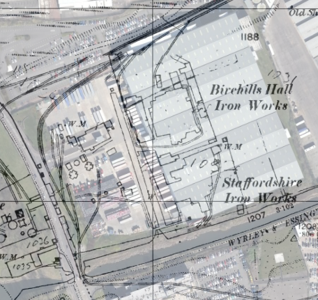 Continue reading
Posted in Environment, Followups, Fun stuff to see and do, Local History, Local media, News, Reader enquiries, Shared media, Shared memories, Spotted whilst browsing the web, Walsall community
Tagged 1886-7, 1903, 1914, 1938, Birchills, Bloxwich, Brick, Canal, Derelict, foundry, Goodall Works, Google Earth, hall, Ironworks, Leamore, Local History, Mapping, Mapps, Old maps, overlay, planning, Redevelopment, Staffordshire, Things to do, Tube, Walsall
21 Comments
Gorgeous curves
Here’s a bit of a request stop. A few weeks ago there was a very positive response to my digitally contouring of an Ordnance Survey map in the analysis of the Watford Gap area near Sutton Coldfield.
I have a bit of clever software that can do this, and access to the mapping data to use as a canvas.
 Continue reading
Posted in Brownhills stuff, Cannock Chase, Chasewater, Environment, Followups, Fun stuff to see and do, Interesting photos, Local media, News, Reader enquiries, Shared media, Social Media, Walsall community, Walsall Wood stuff
Tagged Barr Beacon, Brownhills, Cannock Chase, Chasewater, Contour, Lichfield, Mapping, maps, Ordnance Survey, Relief, Reservoir, Shire Oak, Staffordshire, Stonnall, Things to do, Topografic, Walsall, Walsall Wood
5 Comments
Brownhills and surrounds, in 1920
I thought I’d post a treat for the mapping geeks amongst us (me included) with this 1920 New Popular Edition segment. This is the cartography – all hand drafted – that gave birth to our excellent ‘Landranger’ series. One to … Continue reading
Posted in Brownhills stuff, Environment, Local History, Local media, Shared media, Shared memories, Walsall community, Walsall Wood stuff
Tagged 1920, Brownhills, Brownhills local history, cartography, Local History, Mapping, New popular edition, Old maps, Ordnance Survey, Staffordshire, Walsall, Walsall Wood
6 Comments
Treasured Maps
Since I seem to be having a tad of a catch-up today, I thought I’d share some interesting bits I’d noticed from the old maps I shared with readers last week. In idle moments I’ve been perusing them quite closely, … Continue reading
Posted in Brownhills stuff, Followups, Fun stuff to see and do, Local History, Reader enquiries, Shared media, Shared memories, Walsall Wood stuff
Tagged Anglesey Brindge, Anglesey tramway, Brownhills, Brownhills local history, Castlehill, Castlehill Road, Letocetum, Local History, Mapping, Old maps, old maps of Brownhills, Ordnance Survey, Redevelopment, Sandfields, Wall, Walsall Wood
12 Comments
 RSS - Posts