
 #365daysofbiking Journal
Recent tracks

 Just Turn For HomeGilroy Mere2 hours ago
Moss And YewGilroy Mere2 hours ago
The Green LineGilroy Mere2 hours ago
I Can See The Sea From HereGilroy Mere2 hours ago
On Ditchling BeaconGilroy Mere2 hours ago
A LychgateGilroy Mere2 hours ago
Hop PickersGilroy Mere2 hours ago
RLH48Gilroy Mere2 hours ago
Cuckoo WaltzGilroy Mere2 hours ago
Dunroamin'Gilroy Mere2 hours ago
Just Turn For HomeGilroy Mere2 hours ago
Moss And YewGilroy Mere2 hours ago
The Green LineGilroy Mere2 hours ago
I Can See The Sea From HereGilroy Mere2 hours ago
On Ditchling BeaconGilroy Mere2 hours ago
A LychgateGilroy Mere2 hours ago
Hop PickersGilroy Mere2 hours ago
RLH48Gilroy Mere2 hours ago
Cuckoo WaltzGilroy Mere2 hours ago
Dunroamin'Gilroy Mere2 hours agoRecent Comments
Kevin Wilford on Mount Zion Sunday School Anniv… chrisjimallen on Down the tubes bravelyd03ee3c14f on Celebrating a Jubilee? bravelyd03ee3c14f on Celebrating a Jubilee? Nathan on Raising damp
Tag Archives: overlay
Court out
Here’s a little bit of a curiosity we’ve dabbled with here on the blog for the last few weeks – Silver Court in Brownhills, and the possibility it was once extended.  Continue reading
Posted in Brownhills stuff, Clayhanger stuff, Environment, Followups, Fun stuff to see and do, Interesting photos, Just plain daft, Local History, Local media, News, planning, Reader enquiries, Shared media, Shared memories, Social Media, Spotted whilst browsing the web, Walsall Council
Tagged 1960's, 1:2500, Brownhills, Brownhills local history, Canal, Google Earth, Lichfield, Local History, New Photos, New Road, new Street, Old maps, overlay, planning, Redevelopment, Severn House, Silver Court, Staffordshire, Things to do
12 Comments
Silver caught?
A couple of weeks ago, I posted the following map here of central Brownhills from the late 1960s, in answer to an enquiry tied up with the thread about the Salvation Army Hall in Brownhills – it’s a great map, and at the time it caused quite a bit of interest.
 Continue reading
Posted in Bad Science, Brownhills stuff, Churches, Environment, Events, Followups, Fun stuff to see and do, Interesting photos, Just plain daft, Local History, News, planning, Reader enquiries, Shared media, Shared memories, Spotted whilst browsing the web, Walsall community, Walsall Council
Tagged 1960's, 1:2500, Brownhills, Brownhills local history, Canal, Google Earth, Humphries House, KMZ, Local History, New Photos, New Road, new Street, Old maps, overlay, planning, Redevelopment, Severn House, Silver Court, Staffordshire, Things to do
9 Comments
Down the tubes
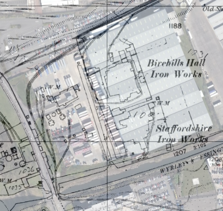
Further to the Birchills Ironworks discussion, I had this interesting contribution from reader and top friend of the blog, Andy Dennis – I’d certainly be interested in any material relating to Sterling Tubes or any other companies operating in the area discussed here last weekend.
 Continue reading
Posted in Environment, Followups, Fun stuff to see and do, Interesting photos, Local History, Local media, News, Reader enquiries, Shared media, Shared memories, Social Media
Tagged Andy Dennis, Birchills, Bloxwich, Canal, Castinds, Deely, Derelict, foundry, hall, Ironworks, Leamore, Local History, Mural, overlay, planning, Redevelopment, Staffordshire, Sterling, Things to do, Tube
28 Comments
The white heat of technology
This weekend, I have been mostly excavating the mapping record for Birchills Iron Works – I know it’s way off our normal beat, but once I started looking at the geography following the remarkable sale post of last Friday, I couldn’t help but be captivated.
 Continue reading
Posted in Environment, Followups, Fun stuff to see and do, Local History, Local media, News, Reader enquiries, Shared media, Shared memories, Spotted whilst browsing the web, Walsall community
Tagged 1886-7, 1903, 1914, 1938, Birchills, Bloxwich, Brick, Canal, Derelict, foundry, Goodall Works, Google Earth, hall, Ironworks, Leamore, Local History, Mapping, Mapps, Old maps, overlay, planning, Redevelopment, Staffordshire, Things to do, Tube, Walsall
21 Comments
 RSS - Posts