
 #365daysofbiking Journal
Recent tracks

 Here I Am NowJohn Martyn14 hours ago
Road To RuinJohn Martyn14 hours ago
Say What You CanJohn Martyn14 hours ago
Road To RuinJohn Martyn14 hours ago
Say What You CanJohn Martyn14 hours ago
Tree GreenJohn Martyn14 hours ago
Sorry To Be So LongJohn Martyn15 hours ago
Give Us A RingJohn Martyn15 hours ago
New DayJohn Martyn15 hours ago
Auntie AviatorJohn Martyn15 hours ago
Here I Am NowJohn Martyn14 hours ago
Road To RuinJohn Martyn14 hours ago
Say What You CanJohn Martyn14 hours ago
Road To RuinJohn Martyn14 hours ago
Say What You CanJohn Martyn14 hours ago
Tree GreenJohn Martyn14 hours ago
Sorry To Be So LongJohn Martyn15 hours ago
Give Us A RingJohn Martyn15 hours ago
New DayJohn Martyn15 hours ago
Auntie AviatorJohn Martyn15 hours agoRecent Comments
Kevin Wilford on Mount Zion Sunday School Anniv… chrisjimallen on Down the tubes bravelyd03ee3c14f on Celebrating a Jubilee? bravelyd03ee3c14f on Celebrating a Jubilee? Nathan on Raising damp
Tag Archives: Vicki Brosh
Squared
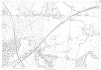
Just a quicky. Here’s an 1883 Ordnance Survey map of the northern half of Brownhills. I dug it out particularly for the lady – Vicki Brosch – who recently asked where Ogley Square was. It can be seen approximately a third of the way across the map from the right, just up from the bottom.
Posted in Brownhills stuff, Churches, Environment, Followups, Local History, Local media, News, Reader enquiries, Shared media, Walsall community
Tagged 1883, 1:2500, Brownhills, Brownhills local history, Local History, Ogley Hay, Ogley Square, Old maps, Ordnance Survey, Pike Helve, Pike Hill, Staffordshire, Things to do, Vicki Brosh
6 Comments
 RSS - Posts