
 #365daysofbiking Journal
Recent tracks

 Vinyl FeverJapancakes4 hours ago
The Sleepy StrangeJapancakes4 hours ago
Soft N EzJapancakes4 hours ago
Vanishing PointJapancakes5 hours ago
This Year's BeatJapancakes5 hours ago
Disconnect the CablesJapancakes5 hours ago
The WaitingJapancakes5 hours ago
Vinyl FeverJapancakes4 hours ago
The Sleepy StrangeJapancakes4 hours ago
Soft N EzJapancakes4 hours ago
Vanishing PointJapancakes5 hours ago
This Year's BeatJapancakes5 hours ago
Disconnect the CablesJapancakes5 hours ago
The WaitingJapancakes5 hours ago Deia Song / LlucalcariFionn Regan5 hours ago
Swimming the Lakes / Flowers and StonesFionn Regan5 hours ago
HEADPHONESFionn Regan5 hours ago
Deia Song / LlucalcariFionn Regan5 hours ago
Swimming the Lakes / Flowers and StonesFionn Regan5 hours ago
HEADPHONESFionn Regan5 hours agoRecent Comments
jennifer Blake on Spurrells: was this a local co… jennifer Blake on The Thacker family, around 193… Paul Bullen on Watling Street School –… Paul Bullen on Watling Street School –… Paul Bullen on Watling Street School –…
Tag Archives: Brownhills Colliey
After the gold rush
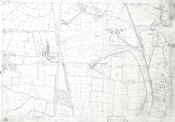
I thought that today, I’d dig some interesting mapping out of the archive. In the light of Gerald Reece’s talk on Brownhills and it’s colliery history, I thought this 1884 1:2,500 scale plan of Wyrley Common was due an outing. It shows – in some clarity – the extent of mining in the Engine Lane area at the height of the Victorian period.
 Continue reading
Posted in Brownhills stuff, Environment, Followups, Local History, News, Shared media, Walsall community
Tagged 1884, 1:2500, Brownhills, Brownhills Colliey, Brownhills local history, Canal, Cathedral Pit, Engine Lane, Gerald Reece, Grove Colliery, Local History, Old maps, Ordnance Survey, Palmers Hay, Staffordshire, Wyrley common
8 Comments
 RSS - Posts
