
 #365daysofbiking Journal
Recent tracks

 Blue SeaChina Crisis4 hours ago
The World Spins, I'm Part Of ItChina Crisis4 hours ago
Bigger The Punch I'm FeelingChina Crisis4 hours ago
King In A Catholic Style (Wake Up)China Crisis4 hours ago
Gift Of FreedomChina Crisis5 hours ago
Wall Of GodChina Crisis5 hours ago
Black Man RayChina Crisis5 hours ago
You Did Cut MeChina Crisis5 hours ago
Strength Of CharacterChina Crisis5 hours ago
The Highest HighChina Crisis5 hours ago
Blue SeaChina Crisis4 hours ago
The World Spins, I'm Part Of ItChina Crisis4 hours ago
Bigger The Punch I'm FeelingChina Crisis4 hours ago
King In A Catholic Style (Wake Up)China Crisis4 hours ago
Gift Of FreedomChina Crisis5 hours ago
Wall Of GodChina Crisis5 hours ago
Black Man RayChina Crisis5 hours ago
You Did Cut MeChina Crisis5 hours ago
Strength Of CharacterChina Crisis5 hours ago
The Highest HighChina Crisis5 hours agoRecent Comments
Philip Ward on Act of Remembrance for those l… Beth Cooksey on Do you remember the Wheatsheaf… Kevin Wilford on Mount Zion Sunday School Anniv… chrisjimallen on Down the tubes bravelyd03ee3c14f on Celebrating a Jubilee?
Tag Archives: Pike Hill
Squared
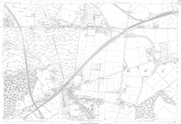
Just a quicky. Here’s an 1883 Ordnance Survey map of the northern half of Brownhills. I dug it out particularly for the lady – Vicki Brosch – who recently asked where Ogley Square was. It can be seen approximately a third of the way across the map from the right, just up from the bottom.
Posted in Brownhills stuff, Churches, Environment, Followups, Local History, Local media, News, Reader enquiries, Shared media, Walsall community
Tagged 1883, 1:2500, Brownhills, Brownhills local history, Local History, Ogley Hay, Ogley Square, Old maps, Ordnance Survey, Pike Helve, Pike Hill, Staffordshire, Things to do, Vicki Brosh
6 Comments
 RSS - Posts