


 #365daysofbiking Journal
Recent tracks

 Hunting DogFionn Regan20 hours ago
Brass LocketFionn Regan20 hours ago
CalaFionn Regan20 hours ago
VolcaFionn Regan20 hours ago
The Ocean WaveFionn Regan20 hours ago
Riverside HeightsFionn Regan20 hours ago
Head SwimFionn Regan20 hours ago
Collar of FurFionn Regan20 hours ago
Hunting DogFionn Regan20 hours ago
Brass LocketFionn Regan20 hours ago
CalaFionn Regan20 hours ago
VolcaFionn Regan20 hours ago
The Ocean WaveFionn Regan20 hours ago
Riverside HeightsFionn Regan20 hours ago
Head SwimFionn Regan20 hours ago
Collar of FurFionn Regan20 hours ago Yesterday's FootprintsJunkboy21 hours ago
FulfilJunkboy21 hours ago
Yesterday's FootprintsJunkboy21 hours ago
FulfilJunkboy21 hours agoRecent Comments
Philip Ward on Act of Remembrance for those l… Beth Cooksey on Do you remember the Wheatsheaf… Kevin Wilford on Mount Zion Sunday School Anniv… chrisjimallen on Down the tubes bravelyd03ee3c14f on Celebrating a Jubilee?
Tag Archives: 1:2500
The Metz office?
An intriguing enquiry reaches me from local historian and blog dynamo the young David Evans, who’s after a rather specific bit of history relating to a lost courtyard of dwellings in Brownhills High Street Called ‘The Metz’.
Posted in Bad Science, Brownhills stuff, Environment, Followups, Fun stuff to see and do, Interesting photos, It makes me mad!, Just plain daft, Local History, Local media, Local politics, News, planning, Reader enquiries, Shared media, Shared memories, Social Media
Tagged 1883, 1:2500, bad housing, Brownhills, Brownhills local history, Brownhills Urban District Council, clearance, David Evans, Dr. Bradford, George Bradford, Hill sisters, Lichfield Mercury, Local History, Metz, Norman Waine, Ogley Hay, Ogley Square, Old maps, Ordnance Survey, Peter Cutler, Richard Burnell, Slum clearance, snaitationG, Staffordshire, Things to do, UDC, Urban District Council
4 Comments
Court out
Here’s a little bit of a curiosity we’ve dabbled with here on the blog for the last few weeks – Silver Court in Brownhills, and the possibility it was once extended.  Continue reading
Posted in Brownhills stuff, Clayhanger stuff, Environment, Followups, Fun stuff to see and do, Interesting photos, Just plain daft, Local History, Local media, News, planning, Reader enquiries, Shared media, Shared memories, Social Media, Spotted whilst browsing the web, Walsall Council
Tagged 1960's, 1:2500, Brownhills, Brownhills local history, Canal, Google Earth, Lichfield, Local History, New Photos, New Road, new Street, Old maps, overlay, planning, Redevelopment, Severn House, Silver Court, Staffordshire, Things to do
12 Comments
Silver caught?
A couple of weeks ago, I posted the following map here of central Brownhills from the late 1960s, in answer to an enquiry tied up with the thread about the Salvation Army Hall in Brownhills – it’s a great map, and at the time it caused quite a bit of interest.
 Continue reading
Posted in Bad Science, Brownhills stuff, Churches, Environment, Events, Followups, Fun stuff to see and do, Interesting photos, Just plain daft, Local History, News, planning, Reader enquiries, Shared media, Shared memories, Spotted whilst browsing the web, Walsall community, Walsall Council
Tagged 1960's, 1:2500, Brownhills, Brownhills local history, Canal, Google Earth, Humphries House, KMZ, Local History, New Photos, New Road, new Street, Old maps, overlay, planning, Redevelopment, Severn House, Silver Court, Staffordshire, Things to do
9 Comments
An unearned income
It is with great pleasure that I can now continue the story of the slum clearance of Ogley Square in 1935, thanks to the efforts of an anonymous reader and top friend of the blog Richard Burnell.
Posted in Bad Science, Brownhills stuff, Environment, Followups, Fun stuff to see and do, Interesting photos, It makes me mad!, Just plain daft, Local History, Local media, Local politics, News, planning, Reader enquiries, Shared media, Shared memories, Social Media
Tagged 1883, 1:2500, bad housing, Brownhills, Brownhills local history, Brownhills Urban District Council, clearance, Dr. Bradford, George Bradford, Hill sisters, Lichfield Mercury, Local History, Norman Waine, Ogley Hay, Ogley Square, Old maps, Ordnance Survey, Peter Cutler, Richard Burnell, Slum clearance, snaitationG, Staffordshire, Things to do, UDC, Urban District Council
6 Comments
Seeing the Wood for the trees
Continuing the paper maps, here’s an 1884 12,500 scale Ordnance Survey map of southern Walsall Wood.
 Continue reading
Posted in Brownhills stuff, Churches, Environment, Followups, Fun stuff to see and do, Local History, Local media, News, Reader enquiries, Shared media, Walsall community, Walsall Wood stuff
Tagged 1884, 1:2500, Brownhills, Brownhills local history, Druids Heath, Local History, Old maps, Ordnance Survey, Staffordshire, Things to do, Walsall Wood
8 Comments
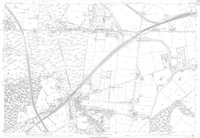
Squared
Just a quicky. Here’s an 1883 Ordnance Survey map of the northern half of Brownhills. I dug it out particularly for the lady – Vicki Brosch – who recently asked where Ogley Square was. It can be seen approximately a third of the way across the map from the right, just up from the bottom.
Posted in Brownhills stuff, Churches, Environment, Followups, Local History, Local media, News, Reader enquiries, Shared media, Walsall community
Tagged 1883, 1:2500, Brownhills, Brownhills local history, Local History, Ogley Hay, Ogley Square, Old maps, Ordnance Survey, Pike Helve, Pike Hill, Staffordshire, Things to do, Vicki Brosh
6 Comments
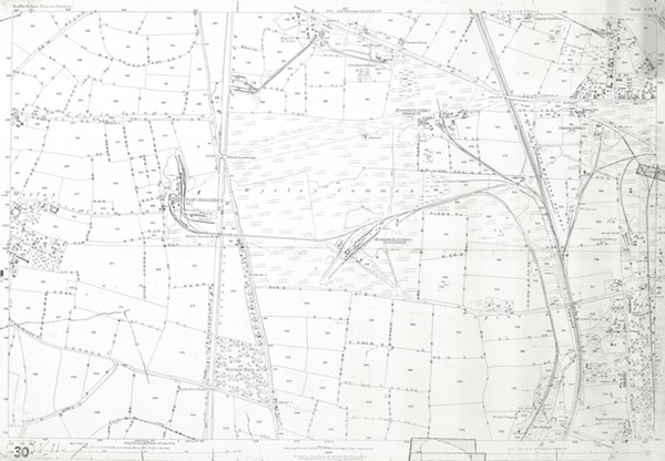
After the gold rush
I thought that today, I’d dig some interesting mapping out of the archive. In the light of Gerald Reece’s talk on Brownhills and it’s colliery history, I thought this 1884 1:2,500 scale plan of Wyrley Common was due an outing. It shows – in some clarity – the extent of mining in the Engine Lane area at the height of the Victorian period.
 Continue reading
Posted in Brownhills stuff, Environment, Followups, Local History, News, Shared media, Walsall community
Tagged 1884, 1:2500, Brownhills, Brownhills Colliey, Brownhills local history, Canal, Cathedral Pit, Engine Lane, Gerald Reece, Grove Colliery, Local History, Old maps, Ordnance Survey, Palmers Hay, Staffordshire, Wyrley common
8 Comments
Wood work
This is a post for top reader, contributor and friend of the blog David Evans. A couple of days ago, he emailed me asking if I had any old maps covering the general Walsall Wood area. Well, it took me … Continue reading
Posted in Brownhills stuff, Environment, Followups, Interesting photos, Local History, Local media, News, Reader enquiries, Shared media, Shared memories, Social Media, Walsall community, Walsall Wood stuff
Tagged 1884, 1902, 1919, 1938, 1:2500, aerial imagery, Aerofilms, Brownhills, Brownhills local history, David Evans, Local History, New Photos, Old maps, Ordnance Survey, Redevelopment, Staffordshire, Walsall Wood
2 Comments
Anglesey Basin and the southern Chasetown area, 1962
Following on from the 1884 Brownhills South and Walsall Wood map and the 1884 Brownhills Common and Central map, I continue the series of paper scanned maps with this gem from 1968 – a 1:2,500 plot of Anglesey Basin and the … Continue reading
Posted in Brownhills stuff, Chasewater, Environment, Features, Followups, Fun stuff to see and do, Local History, Local media, Shared media, Shared memories, Walsall community, Walsall Wood stuff
Tagged 1962, 1:2500, Anglesey Basin, Anglesey Wharf, Brownhills, Brownhills local history, Canal, Chasetown, Chasewater, Chasewater Dam, Local History, mining, Old maps, OS Map, Reservoir, scanned maps, Staffordshire, Triangle
2 Comments
Aldridge north west, 1884 and 1914
Following on from the 1884 Brownhills South and Walsall Wood map and others posted recently, I’ve dived into the digital archive after a request by reader Mike Hawes and pulled out the 1:2,500 scale gems from 1884 and 1914. They show … Continue reading
Posted in Environment, Features, Followups, Fun stuff to see and do, Local History, Local media, Reader enquiries, Shared media, Shared memories, Social Media, Walsall community, Walsall Wood stuff
Tagged 1884, 1914, 1:2500, Aldridge, Brownhills, Canal, David Evans, Dumblederry, Leighs Wood, Local History, map, Mike Hawes, mining, Old maps, Ordnance Survey, OS Map, scanned maps, Staffordshire
4 Comments
 RSS - Posts