Subscribe to Blog via Email
Join 5,250 other subscribers-
Search the blog:
Top Posts & Pages
Archives
#365daysofbiking Journal
Activism
Blogs & Stuff I like
Cycle stuff
Funny stuff
Local History
Local press
Local sites
Urban Exploration
Blog Stats
- 7,333,683 hits
Recent tracks
Good Morning Starshine
Lynn Kellogg, James Rado & Gerome Ragni
11 monthsGood Morning Starshine
Lynn Kellogg, James Rado & Gerome Ragni
1 yearFor
C. Duncan
1 yearThat Voice Again
Peter Gabriel
1 yearLiving By Numbers
New Musik
1 yearSequestered In Memphis
The Hold Steady
1 yearGood Morning Starshine
Lynn Kellogg, James Rado & Gerome Ragni
1 yearRunning
Technicolor
1 yearTonband Laufspur
Kosmischer Läufer
1 yearLast Night Of The World
Bruce Cockburn
1 yearRecent Comments
Sue on Chasewater Stadium – wha… Steve Stackhouse on Taylor made memories Leslie Winstanley on Taylor made memories Stephen Stackhouse on Taylor made memories Michelle on Taylor made memories
Tag Archives: Google Earth
Court out
Here’s a little bit of a curiosity we’ve dabbled with here on the blog for the last few weeks – Silver Court in Brownhills, and the possibility it was once extended. Continue reading →
Posted in Brownhills stuff, Clayhanger stuff, Environment, Followups, Fun stuff to see and do, Interesting photos, Just plain daft, Local History, Local media, News, planning, Reader enquiries, Shared media, Shared memories, Social Media, Spotted whilst browsing the web, Walsall Council
|
Tagged 1960's, 1:2500, Brownhills, Brownhills local history, Canal, Google Earth, Lichfield, Local History, New Photos, New Road, new Street, Old maps, overlay, planning, Redevelopment, Severn House, Silver Court, Staffordshire, Things to do
|
12 Comments
Silver caught?
A couple of weeks ago, I posted the following map here of central Brownhills from the late 1960s, in answer to an enquiry tied up with the thread about the Salvation Army Hall in Brownhills – it’s a great map, and at the time it caused quite a bit of interest.
Continue reading →
Posted in Bad Science, Brownhills stuff, Churches, Environment, Events, Followups, Fun stuff to see and do, Interesting photos, Just plain daft, Local History, News, planning, Reader enquiries, Shared media, Shared memories, Spotted whilst browsing the web, Walsall community, Walsall Council
|
Tagged 1960's, 1:2500, Brownhills, Brownhills local history, Canal, Google Earth, Humphries House, KMZ, Local History, New Photos, New Road, new Street, Old maps, overlay, planning, Redevelopment, Severn House, Silver Court, Staffordshire, Things to do
|
9 Comments
The white heat of technology
This weekend, I have been mostly excavating the mapping record for Birchills Iron Works – I know it’s way off our normal beat, but once I started looking at the geography following the remarkable sale post of last Friday, I couldn’t help but be captivated.
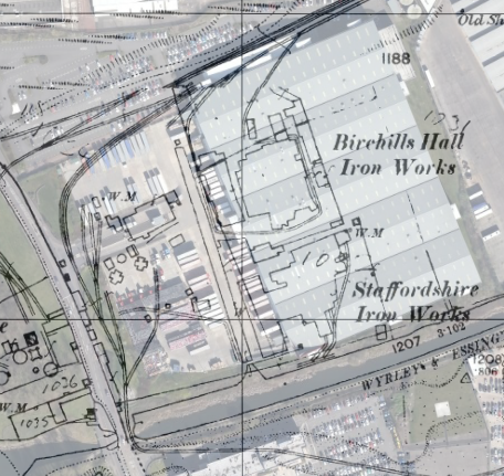
Continue reading →
Posted in Environment, Followups, Fun stuff to see and do, Local History, Local media, News, Reader enquiries, Shared media, Shared memories, Spotted whilst browsing the web, Walsall community
|
Tagged 1886-7, 1903, 1914, 1938, Birchills, Bloxwich, Brick, Canal, Derelict, foundry, Goodall Works, Google Earth, hall, Ironworks, Leamore, Local History, Mapping, Mapps, Old maps, overlay, planning, Redevelopment, Staffordshire, Things to do, Tube, Walsall
|
21 Comments
Grange rover
Further to the discussion about The Grange in Leighswood, Aldridge, in the wee small hours I had a play with overlaying the relevant maps on Google Earth imagery to find out exactly where the property stood. I overlaid the 1961 … Continue reading →
Posted in Environment, Followups, Fun stuff to see and do, Local Blogs, Local History, Local media, News, Reader enquiries, Shared media, Shared memories, Social Media, Spotted whilst browsing the web, Walsall community, Walsall Wood stuff
|
Tagged 1956, 1971, Aldridge, Birmingham History Forum, David Evans, Google Earth, Lazy Hill, Leighswood, Local History, Mary Woodroffe, New Photos, Northgate, Old maps, Ordnance Survey, overlay, Pennard, Redevelopment, Staffordshire, The Grange, Things to do, Walsall Wood, Walsall Wood Road, Walton Road
|
10 Comments
On solid ground
Here’s a real find. I recently acquired a couple of railway plans from my favourite map dealer, and bought them blind. I actually thought one was of Walsall Wood, and the other was Brownhills West, due to the drawing titles. … Continue reading →
Posted in Brownhills stuff, Environment, Followups, Fun stuff to see and do, Interesting photos, Local History, News, Shared media, Shared memories
|
Tagged 1960, British Railways Board, Brownhills, Brownhills local history, Brownhills West Colliery, Canal, Derelict, Draft, Engine Lane, geological engineers, Google Earth, Harrison Sidings, Local History, M Fltcher, mining, Norton Branch, Old canal, Old maps, overlay, plan, shafts, Things to do, vellum paper, Watling Street, workings, Yard Seam
|
7 Comments
Aldridge? We can see right through you…
Reader Mike Hawes requested that I do the Google Earth overlay trick with last weekend’s Aldridge Northwest 1914 map, so I’ve done just that. This was a very difficult one to align, as something seems erroneous about the drafting of … Continue reading →
Posted in Environment, Events, Followups, Fun stuff to see and do, Local History, Local media, News, Reader enquiries, Shared media, Shared memories, Social Media, Walsall community, Walsall Wood stuff
|
Tagged Aldridge, Canal, Common, Dumblederry, Google Earth, GPS basemap, KMZ, Leighswood, Local History, Mike Hawes, mining, old map, Old maps, OS Map, overlay, scanned maps, Staffordshire
|
4 Comments
Mapping transparency
I’ve received a few requests to do the Google Earth overlay trick with yesterday’s Pelsall North and West Brownhills map, so I’ve done just that. Please bear in mind that this was a scan of a paper map, which is … Continue reading →
Posted in Brownhills stuff, Environment, Features, Followups, Fun stuff to see and do, Local History, Local media, Reader enquiries, Shared media, Shared memories, Social Media, Walsall community
|
Tagged 1:1250, Brownhills, Brownhills local history, Canal, Common, David Evans, Gilpin Arm, Google Earth, GPS basemap, KMZ, Local History, mining, Old maps, OS Map, overlay, Pelsall, Pelsall North, scanned maps, Staffordshire
|
2 Comments
Weaving my ancestor’s voices
If this blog is about anything at all, it’s about just how relevant our local history is to what we do, are and feel today. I passionately believe that exploring our collective past can teach us things about the present … Continue reading →
Posted in Brownhills stuff, cycling, Environment, Features, Followups, Fun stuff to see and do, Interesting photos, Local History, Reader enquiries, Shared media, Shared memories, Social Media, Walsall community
|
Tagged 1884, 1919, 1938, 1962, 1:2500, Brownhills, Brownhills common, Brownhills local history, colliery, Custom Maps, Cycle rides, Derelict, Garmin, Google Earth, KMZ, landscape, Local History, mining, mining in brownhills, Old maps, Ornance Survey, overlay, pits, pitshaft, Redevelopment, Staffordshire
|
4 Comments
I can turn back time…
One of the things that has really proved inspirational to me in the creation of this blog is Google Earth. As a young kid, long before computers could do anything remotely like even the most basic mapping, I was was … Continue reading →
Posted in Brownhills stuff, Environment, Followups, Fun stuff to see and do, Interesting photos, Local History, Local media, Shared media, Spotted whilst browsing the web
|
Tagged 1945 aerial photos, Brownhills, Brownhills local history, Google Earth, Google Earth 6, how to view historic imagery in Google Earth, Local History, New Photos, old aerial phtography, Old maps
|
9 Comments
A la carte
Maps provide a strong, almost incontestable record of the physical history of a place. They show us what came, what went, what was gained, and what was lost. Here in Britain, we have one of the best provisioners of cartography … Continue reading →
Posted in Brownhills stuff, Chasewater, Churches, Clayhanger stuff, Environment, Followups, Fun stuff to see and do, Local History, Reader enquiries, Shared media, Shared memories, Walsall Wood stuff
|
Tagged 1:25000 1948, 1:25000 1951, Brownhills maps, David Archer Maps, Google Earth, Google Earth overlays, Lichfield maps, Mapping, maps, Old maps, Ordnance Survey, SK00, SK10
|
7 Comments
Google Streetview comes to Brownhills
Fiddling with Google Earth this evening, I’ve noticed with some delight that the Streetview feature has been enabled for huge sections of our local area. For anyone intrinsically nosey, like me, this is set to provide hours of amusement. At … Continue reading →
Posted in Brownhills stuff, Environment, Fun stuff to see and do, Local media, Shared media, Spotted whilst browsing the web
|
Tagged Brownhills, Google Earth, Streetview
|
2 Comments
Mapping the past – now for something completely different.
I’ve been fiddling for some time now with digital maps. I’ve always loved their paper forebears; a map is a promise, a portent of future exploration, a pointer to places and journeys yet to be experienced. When I open a … Continue reading →
Posted in Brownhills stuff, Chasewater, Clayhanger stuff, cycling, Environment, Fun stuff to see and do, Local History, Local media, Shared media, Walsall Wood stuff
|
Tagged Brownhills, Brownhills local history, Brownhills maps, Clayhanger, Custom Maps, digital maps, Garmin, Google Earth, Google Earth overlay, GPS, Local History, Old maps, old maps of Brownhills, Ordnance Survey, Oregon, OS, Panoramio, Shire Oak, Staffordshire, Walsall Wood
|
23 Comments