
 #365daysofbiking Journal
Recent tracks

 KazooAshra18 minutes ago
SausalitoAshra22 minutes ago
AerogenAshra26 minutes ago
BoomerangAshra30 minutes ago
ScreamerAshra34 minutes ago
WuduAshra37 minutes ago
KazooAshra18 minutes ago
SausalitoAshra22 minutes ago
AerogenAshra26 minutes ago
BoomerangAshra30 minutes ago
ScreamerAshra34 minutes ago
WuduAshra37 minutes ago Angie’s WeddingAntony Szmierek1 hour ago
Crashing UpAntony Szmierek1 hour ago
Restless Leg SyndromeAntony Szmierek1 hour ago
Take Me ThereAntony Szmierek1 hour ago
Angie’s WeddingAntony Szmierek1 hour ago
Crashing UpAntony Szmierek1 hour ago
Restless Leg SyndromeAntony Szmierek1 hour ago
Take Me ThereAntony Szmierek1 hour agoRecent Comments
Dean on Those Craddocks in full… Dean on Those Craddocks in full… Sue on Those Craddocks in full… Dean on Those Craddocks in full… Dean on Those Craddocks in full…
Tag Archives: 1884
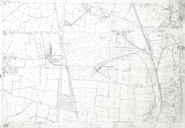
A conduit for change
A quick but interesting one – I’ve just dredged the above map out of my stash – this one has a gruesome correction tear, but it shows Norton pretty much as it would have been when the journalist writing for The Graphic visited in 1886.
 Continue reading
Posted in Environment, Followups, Fun stuff to see and do, Local History, Local media, News, Reader enquiries, Shared media, Shared memories
Tagged 1884, Canal, Canes, Chasewater, colliery, Conduit, Local History, map, Norton, Old maps, pit, Redevelopment, Staffordshire, Things to do
Leave a comment
Supporting services
It’s been a while since I did a mapping post here on the blog, and yesterday, whilst visiting the open day at Christchurch, in Leomonsley, I saw a huge copy of the 1884 OS map of Lichfield that inspired me. If you ever get chance to see it, do so. A beautiful, A0-size hand-tinted copy, clearly for ecclesiastical use. A thing of rare and immense beauty.
 Continue reading
Posted in Churches, cycling, Environment, Followups, Fun stuff to see and do, Just plain daft, Local Blogs, Local History, Local media, News, Shared media, Shared memories, Social Media
Tagged 1884, 1902, 1928, 1965, Bison, Canal, Chappells, Christchurch, Cross City, Cycle rides, Dovehousfield, Events, Leamonsley, Lichfield, Lichfield Lore, local blogs, Local History, Old maps, Ordnance Survey, Sandfields, Silly, Sloppy Wood, South Staffordshire, south staffordshire water, Staffordshire, Things to do
17 Comments
Seeing the Wood for the trees
Continuing the paper maps, here’s an 1884 12,500 scale Ordnance Survey map of southern Walsall Wood.
 Continue reading
Posted in Brownhills stuff, Churches, Environment, Followups, Fun stuff to see and do, Local History, Local media, News, Reader enquiries, Shared media, Walsall community, Walsall Wood stuff
Tagged 1884, 1:2500, Brownhills, Brownhills local history, Druids Heath, Local History, Old maps, Ordnance Survey, Staffordshire, Things to do, Walsall Wood
8 Comments
After the gold rush
I thought that today, I’d dig some interesting mapping out of the archive. In the light of Gerald Reece’s talk on Brownhills and it’s colliery history, I thought this 1884 1:2,500 scale plan of Wyrley Common was due an outing. It shows – in some clarity – the extent of mining in the Engine Lane area at the height of the Victorian period.
 Continue reading
Posted in Brownhills stuff, Environment, Followups, Local History, News, Shared media, Walsall community
Tagged 1884, 1:2500, Brownhills, Brownhills Colliey, Brownhills local history, Canal, Cathedral Pit, Engine Lane, Gerald Reece, Grove Colliery, Local History, Old maps, Ordnance Survey, Palmers Hay, Staffordshire, Wyrley common
8 Comments
Wood work
This is a post for top reader, contributor and friend of the blog David Evans. A couple of days ago, he emailed me asking if I had any old maps covering the general Walsall Wood area. Well, it took me … Continue reading
Posted in Brownhills stuff, Environment, Followups, Interesting photos, Local History, Local media, News, Reader enquiries, Shared media, Shared memories, Social Media, Walsall community, Walsall Wood stuff
Tagged 1884, 1902, 1919, 1938, 1:2500, aerial imagery, Aerofilms, Brownhills, Brownhills local history, David Evans, Local History, New Photos, Old maps, Ordnance Survey, Redevelopment, Staffordshire, Walsall Wood
2 Comments
Face to face
Following on from my post last week where I featured local historian Gerald Reece’s research and loving reproductions of the mapping for the the proposed Norton Branch of the South Staffordshire Railway, I have an interesting document to share with … Continue reading
Posted in Brownhills stuff, Cannock Chase, Environment, Followups, Fun stuff to see and do, Interesting photos, Local Blogs, Local History, Local media, News, Shared media, Shared memories, Spotted whilst browsing the web, Walsall community
Tagged 1884, Bettys Lane, Brownhills, Brownhills local history, Canal, Cannock Chase Mining Historical Society, Conduit Colliery, Conduit colliery basin, Document, Draft, Gerald Reece, history, local blogs, Local History, London North Western Railway, mining, New Photos, Norton Branch, Norton Canes, Old maps, plan, Pubs, Railway, Red Lion, Redevelopment, South Staffordshire Raiway, Staffordshire
10 Comments
Aldridge north west, 1884 and 1914
Following on from the 1884 Brownhills South and Walsall Wood map and others posted recently, I’ve dived into the digital archive after a request by reader Mike Hawes and pulled out the 1:2,500 scale gems from 1884 and 1914. They show … Continue reading
Posted in Environment, Features, Followups, Fun stuff to see and do, Local History, Local media, Reader enquiries, Shared media, Shared memories, Social Media, Walsall community, Walsall Wood stuff
Tagged 1884, 1914, 1:2500, Aldridge, Brownhills, Canal, David Evans, Dumblederry, Leighs Wood, Local History, map, Mike Hawes, mining, Old maps, Ordnance Survey, OS Map, scanned maps, Staffordshire
4 Comments
Brownhills Common and Central, 1884.
Following on from the 1884 Brownhills South and Walsall Wood map of last week, I have one that will interest those wanting to investigate the mining history on Brownhills Common. This is an 1884 1:1250 plot of that area in … Continue reading
Posted in Brownhills stuff, Environment, Features, Followups, Fun stuff to see and do, Local History, Local media, Shared media, Shared memories, Walsall community, Walsall Wood stuff
Tagged 1884, 1:1250, Brownhills, Brownhills Colliery, Brownhills local history, Canal, Cathedral Pit, Common, Conduit Pit, David Evans, Local History, mining, Old maps, OS Map, Rose Villa, scanned maps, Staffordshire
4 Comments
 RSS - Posts