Subscribe to Blog via Email
Join 953 other subscribers-
Search the blog:
Top Posts & Pages
Archives
#365daysofbiking JournalActivism
Blogs & Stuff I like
Cycle stuff
Funny stuff
Local History
Local press
Local sites
Urban Exploration
Blog Stats
- 7,648,786 hits
Recent tracks
Everybody ScreamFlorence + the Machine3 hours ago
Sweet DispositionThe Temper Trap3 hours ago
Spike IslandPulp3 hours ago
On CallKings of Leon3 hours ago
I'm Your ManLeonard Cohen3 hours ago
Darkness, DarknessThe Third Mind3 hours ago
Jah WorkBen Harper3 hours ago
Zion ICymande3 hours ago
Moments (Part 2)FKJ3 hours ago
Running From MercyRickie Lee Jones3 hours agoRecent Comments
Simon Pearce on The Hawthorn and William Pierc… Paul Markham on On the ‘Shawe Steve Green on A sad announcement Michael Edwards. on Former Shire Oak Pupils Celebr… Angela Hallbrook on A sunny morning in Pier Street
Tag Archives: overlay
Court out
Here’s a little bit of a curiosity we’ve dabbled with here on the blog for the last few weeks – Silver Court in Brownhills, and the possibility it was once extended.
Continue reading →
Share this:
- Share on X (Opens in new window) X
- Share on Pinterest (Opens in new window) Pinterest
- Email a link to a friend (Opens in new window) Email
- Share on Facebook (Opens in new window) Facebook
- Share on Reddit (Opens in new window) Reddit
- Print (Opens in new window) Print
- Share on Tumblr (Opens in new window) Tumblr
Posted in Brownhills stuff, Clayhanger stuff, Environment, Followups, Fun stuff to see and do, Interesting photos, Just plain daft, Local History, Local media, News, planning, Reader enquiries, Shared media, Shared memories, Social Media, Spotted whilst browsing the web, Walsall Council
|
Tagged 1960's, 1:2500, Brownhills, Brownhills local history, Canal, Google Earth, Lichfield, Local History, New Photos, New Road, new Street, Old maps, overlay, planning, Redevelopment, Severn House, Silver Court, Staffordshire, Things to do
|
12 Comments
Silver caught?
A couple of weeks ago, I posted the following map here of central Brownhills from the late 1960s, in answer to an enquiry tied up with the thread about the Salvation Army Hall in Brownhills – it’s a great map, and at the time it caused quite a bit of interest.
Continue reading →
Share this:
- Share on X (Opens in new window) X
- Share on Pinterest (Opens in new window) Pinterest
- Email a link to a friend (Opens in new window) Email
- Share on Facebook (Opens in new window) Facebook
- Share on Reddit (Opens in new window) Reddit
- Print (Opens in new window) Print
- Share on Tumblr (Opens in new window) Tumblr
Posted in Bad Science, Brownhills stuff, Churches, Environment, Events, Followups, Fun stuff to see and do, Interesting photos, Just plain daft, Local History, News, planning, Reader enquiries, Shared media, Shared memories, Spotted whilst browsing the web, Walsall community, Walsall Council
|
Tagged 1960's, 1:2500, Brownhills, Brownhills local history, Canal, Google Earth, Humphries House, KMZ, Local History, New Photos, New Road, new Street, Old maps, overlay, planning, Redevelopment, Severn House, Silver Court, Staffordshire, Things to do
|
9 Comments
Down the tubes
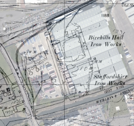
Further to the Birchills Ironworks discussion, I had this interesting contribution from reader and top friend of the blog, Andy Dennis – I’d certainly be interested in any material relating to Sterling Tubes or any other companies operating in the area discussed here last weekend.
Continue reading →
Share this:
- Share on X (Opens in new window) X
- Share on Pinterest (Opens in new window) Pinterest
- Email a link to a friend (Opens in new window) Email
- Share on Facebook (Opens in new window) Facebook
- Share on Reddit (Opens in new window) Reddit
- Print (Opens in new window) Print
- Share on Tumblr (Opens in new window) Tumblr
Posted in Environment, Followups, Fun stuff to see and do, Interesting photos, Local History, Local media, News, Reader enquiries, Shared media, Shared memories, Social Media
|
Tagged Andy Dennis, Birchills, Bloxwich, Canal, Castinds, Deely, Derelict, foundry, hall, Ironworks, Leamore, Local History, Mural, overlay, planning, Redevelopment, Staffordshire, Sterling, Things to do, Tube
|
27 Comments
The white heat of technology
This weekend, I have been mostly excavating the mapping record for Birchills Iron Works – I know it’s way off our normal beat, but once I started looking at the geography following the remarkable sale post of last Friday, I couldn’t help but be captivated.
Continue reading →
Share this:
- Share on X (Opens in new window) X
- Share on Pinterest (Opens in new window) Pinterest
- Email a link to a friend (Opens in new window) Email
- Share on Facebook (Opens in new window) Facebook
- Share on Reddit (Opens in new window) Reddit
- Print (Opens in new window) Print
- Share on Tumblr (Opens in new window) Tumblr
Posted in Environment, Followups, Fun stuff to see and do, Local History, Local media, News, Reader enquiries, Shared media, Shared memories, Spotted whilst browsing the web, Walsall community
|
Tagged 1886-7, 1903, 1914, 1938, Birchills, Bloxwich, Brick, Canal, Derelict, foundry, Goodall Works, Google Earth, hall, Ironworks, Leamore, Local History, Mapping, Mapps, Old maps, overlay, planning, Redevelopment, Staffordshire, Things to do, Tube, Walsall
|
21 Comments
Grange rover
Further to the discussion about The Grange in Leighswood, Aldridge, in the wee small hours I had a play with overlaying the relevant maps on Google Earth imagery to find out exactly where the property stood. I overlaid the 1961 … Continue reading →
Share this:
- Share on X (Opens in new window) X
- Share on Pinterest (Opens in new window) Pinterest
- Email a link to a friend (Opens in new window) Email
- Share on Facebook (Opens in new window) Facebook
- Share on Reddit (Opens in new window) Reddit
- Print (Opens in new window) Print
- Share on Tumblr (Opens in new window) Tumblr
Posted in Environment, Followups, Fun stuff to see and do, Local Blogs, Local History, Local media, News, Reader enquiries, Shared media, Shared memories, Social Media, Spotted whilst browsing the web, Walsall community, Walsall Wood stuff
|
Tagged 1956, 1971, Aldridge, Birmingham History Forum, David Evans, Google Earth, Lazy Hill, Leighswood, Local History, Mary Woodroffe, New Photos, Northgate, Old maps, Ordnance Survey, overlay, Pennard, Redevelopment, Staffordshire, The Grange, Things to do, Walsall Wood, Walsall Wood Road, Walton Road
|
10 Comments
On solid ground
Here’s a real find. I recently acquired a couple of railway plans from my favourite map dealer, and bought them blind. I actually thought one was of Walsall Wood, and the other was Brownhills West, due to the drawing titles. … Continue reading →
Share this:
- Share on X (Opens in new window) X
- Share on Pinterest (Opens in new window) Pinterest
- Email a link to a friend (Opens in new window) Email
- Share on Facebook (Opens in new window) Facebook
- Share on Reddit (Opens in new window) Reddit
- Print (Opens in new window) Print
- Share on Tumblr (Opens in new window) Tumblr
Posted in Brownhills stuff, Environment, Followups, Fun stuff to see and do, Interesting photos, Local History, News, Shared media, Shared memories
|
Tagged 1960, British Railways Board, Brownhills, Brownhills local history, Brownhills West Colliery, Canal, Derelict, Draft, Engine Lane, geological engineers, Google Earth, Harrison Sidings, Local History, M Fltcher, mining, Norton Branch, Old canal, Old maps, overlay, plan, shafts, Things to do, vellum paper, Watling Street, workings, Yard Seam
|
7 Comments
Aldridge? We can see right through you…
Reader Mike Hawes requested that I do the Google Earth overlay trick with last weekend’s Aldridge Northwest 1914 map, so I’ve done just that. This was a very difficult one to align, as something seems erroneous about the drafting of … Continue reading →
Share this:
- Share on X (Opens in new window) X
- Share on Pinterest (Opens in new window) Pinterest
- Email a link to a friend (Opens in new window) Email
- Share on Facebook (Opens in new window) Facebook
- Share on Reddit (Opens in new window) Reddit
- Print (Opens in new window) Print
- Share on Tumblr (Opens in new window) Tumblr
Posted in Environment, Events, Followups, Fun stuff to see and do, Local History, Local media, News, Reader enquiries, Shared media, Shared memories, Social Media, Walsall community, Walsall Wood stuff
|
Tagged Aldridge, Canal, Common, Dumblederry, Google Earth, GPS basemap, KMZ, Leighswood, Local History, Mike Hawes, mining, old map, Old maps, OS Map, overlay, scanned maps, Staffordshire
|
4 Comments
Mapping transparency
I’ve received a few requests to do the Google Earth overlay trick with yesterday’s Pelsall North and West Brownhills map, so I’ve done just that. Please bear in mind that this was a scan of a paper map, which is … Continue reading →
Share this:
- Share on X (Opens in new window) X
- Share on Pinterest (Opens in new window) Pinterest
- Email a link to a friend (Opens in new window) Email
- Share on Facebook (Opens in new window) Facebook
- Share on Reddit (Opens in new window) Reddit
- Print (Opens in new window) Print
- Share on Tumblr (Opens in new window) Tumblr
Posted in Brownhills stuff, Environment, Features, Followups, Fun stuff to see and do, Local History, Local media, Reader enquiries, Shared media, Shared memories, Social Media, Walsall community
|
Tagged 1:1250, Brownhills, Brownhills local history, Canal, Common, David Evans, Gilpin Arm, Google Earth, GPS basemap, KMZ, Local History, mining, Old maps, OS Map, overlay, Pelsall, Pelsall North, scanned maps, Staffordshire
|
2 Comments
Weaving my ancestor’s voices
If this blog is about anything at all, it’s about just how relevant our local history is to what we do, are and feel today. I passionately believe that exploring our collective past can teach us things about the present … Continue reading →
Share this:
- Share on X (Opens in new window) X
- Share on Pinterest (Opens in new window) Pinterest
- Email a link to a friend (Opens in new window) Email
- Share on Facebook (Opens in new window) Facebook
- Share on Reddit (Opens in new window) Reddit
- Print (Opens in new window) Print
- Share on Tumblr (Opens in new window) Tumblr
Posted in Brownhills stuff, cycling, Environment, Features, Followups, Fun stuff to see and do, Interesting photos, Local History, Reader enquiries, Shared media, Shared memories, Social Media, Walsall community
|
Tagged 1884, 1919, 1938, 1962, 1:2500, Brownhills, Brownhills common, Brownhills local history, colliery, Custom Maps, Cycle rides, Derelict, Garmin, Google Earth, KMZ, landscape, Local History, mining, mining in brownhills, Old maps, Ornance Survey, overlay, pits, pitshaft, Redevelopment, Staffordshire
|
4 Comments
RSS - Posts