Subscribe to Blog via Email
Join 905 other subscribers-
Search the blog:
Top Posts & Pages
Archives
 #365daysofbiking Journal
Activism
Blogs & Stuff I like
Cycle stuff
Funny stuff
Local History
Local press
Local sites
Urban Exploration
Blog Stats
- 7,467,164 hits
Recent tracks

 Time & Place
Queens of the Stone Age
5 days never too late
thenewno2
5 days This Year's Girl
Elvis Costello
5 days Got My Mojo Workin'
Muddy Waters
5 days Tamacun
Rodrigo y Gabriela
5 days Little Wing
Stevie Ray Vaughan and Double Trouble
5 days Good Love (w/ Billy Gibbons)
The Black Keys
5 days Don’t Ever Let Nobody Drag Your Spirit Down
Eric Burdon
5 days So Much Trouble In The World
Bob Marley
5 days Carolina Low
The Decemberists
5 daysRecent Comments
Marauder on 1987: The end of a landmark Elizabeth Thomson on Made of bricks Gary Huskisson on When the lights go out Nichelle Smith on The Red, White and Blue: what… Jane Henry on The long march: 50 years of ja…
Tag Archives: download
Sunshine after rain
Here’s a great piece of local history I’m proud and happy to feature here on the blog for readers to peruse: the autobiography of local lady and community champion Gwen James.
Posted in Brownhills stuff, Environment, Followups, Fun stuff to see and do, Interesting photos, It makes me mad!, Local History, Local media, Local politics, News, Reader enquiries, Shared media, Spotted whilst browsing the web, Walsall community
Tagged 2015, Autobiography, Brownhills, Brownhills local history, Clayhanger, David Evans, David Hodkinson, download, e book, Gwen james, Lichfield, Local History, New Photos, Staffordshire, Sunshine after Rain, Things to do
8 Comments
Your guide to Walsall – 125 years ago
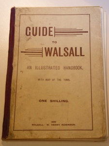
Here’s one I’ve been meaning to do for ages, but the sheer labour of it has been off-putting; but now I have access to a professional scanner, it’s a lot easier to scan publications like W Henry Robinson’s ‘Guide to Walsall – an illustrated guide’, which was published in 1889 and is a captivating gazetteer and document of a growing town and its life.
Continue reading
Posted in Churches, Environment, Fun stuff to see and do, Interesting photos, Local History, Local media, News, Reader enquiries, Shared media, Shared memories, Social Media, Walsall community, Walsall Council
Tagged Book, Canal, download, Facebook, Guide to Waslall, Illustrated Handbook, Lichfield, Local History, Local politics, New Photos, Old maps, PDF, Pubs, Redevelopment, Staffordshire, Things to do, W Henry Robinson, Walsall, Walsall Council, Walsall politics
9 Comments
Rock and coal
Here’s one that is certain to create debate, comment and further articles. Alerted to it in the last week by both Gareth Thomas (Geographical whizz from Lichfield District Council) and Paul Daniel (data whizz behind the mechanism that keeps local news site The YamYam running so brilliantly), it’s a book scanned and published by that wonderful resource Google Books.
Posted in Brownhills stuff, Cannock Chase, Chasewater, Clayhanger stuff, Environment, Features, Followups, Fun stuff to see and do, Local History, Local media, Reader enquiries, Shared media, Social Media, Spotted whilst browsing the web, Walsall community, Walsall Wood stuff
Tagged BGS, Book, Brownhills, Brownhills local history, Chasewater, Clayhanger, coal, Common, download, Engine Lane, Geological Survey of Great Britain, J Beete Jukes, local blogs, Local History, mines, mining, Museum of Practical Geology, Old maps, Shire Oak, South Staffordshire Coal Field, Staffordshire, Things to do, Twitter, Victorian, Walsall Wood
2 Comments
Carte art
Here’s a quick one for the Lichfield historical buffs: John Snape’s map of the city and it’s environs, from 1781. This really is a wonderful work of art, and bears poring over. If you’re into Lichfield’s fascinating and long history, … Continue reading
Posted in Churches, Environment, Local History, Local media, News, Shared media
Tagged 1981, download, hi-res, john, Lichfield, Lichfield History, local blogs, Local History, Lore, map, Old maps, PDF, Snape, Staffordshire
6 Comments
Carte Blanche
Following recent posts in which I made available the William Yates 1798 map of Staffordshire and a 1959 Ordnance Survey map of East Staffordshire, I’ve now got further mapping goodness here for readers to download. This map is an odd … Continue reading
Posted in Brownhills stuff, Cannock Chase, Environment, Features, Followups, Fun stuff to see and do, Local History, Reader enquiries, Shared media, Shared memories, Walsall community
Tagged 179 The Strand, 1798 Staffoedshire Map, 1801 Staffordshire Map, Brownhills, Brownhills local history, C Smith, Canal, Cannock, download, early maps, Improved Map, Local History, map, Old maps, Stafford, Staffordshire, Walsall, William Yates, Yates map
2 Comments
Unfolding the map
As promised earlier in the week, I’ve had some interesting maps, including a reproduction A1 size copy of the 1798 William Yates map of Staffordshire, scanned professionally. I came home today clutching a USB flash drive with nearly four gigabytes … Continue reading
Posted in Brownhills stuff, Cannock Chase, Environment, Features, Followups, Fun stuff to see and do, Local History, Reader enquiries, Shared media, Shared memories, Walsall community
Tagged 1798 Staffoedshire Map, Brownhills, Brownhills local history, Canal, Cannock, Cats Hall, Catshill, download, early maps, Improved Map, Local History, map, Old maps, Stafford, Staffordshire, Walsall, William Yates, Yates map
36 Comments


 RSS - Posts