
 #365daysofbiking Journal
Recent tracks

 Vinyl FeverJapancakes8 hours ago
The Sleepy StrangeJapancakes8 hours ago
Soft N EzJapancakes8 hours ago
Vanishing PointJapancakes8 hours ago
This Year's BeatJapancakes8 hours ago
Disconnect the CablesJapancakes8 hours ago
The WaitingJapancakes8 hours ago
Vinyl FeverJapancakes9 hours ago
The Sleepy StrangeJapancakes9 hours ago
Soft N EzJapancakes9 hours ago
Vinyl FeverJapancakes8 hours ago
The Sleepy StrangeJapancakes8 hours ago
Soft N EzJapancakes8 hours ago
Vanishing PointJapancakes8 hours ago
This Year's BeatJapancakes8 hours ago
Disconnect the CablesJapancakes8 hours ago
The WaitingJapancakes8 hours ago
Vinyl FeverJapancakes9 hours ago
The Sleepy StrangeJapancakes9 hours ago
Soft N EzJapancakes9 hours agoRecent Comments
Philip Ward on Act of Remembrance for those l… Beth Cooksey on Do you remember the Wheatsheaf… Kevin Wilford on Mount Zion Sunday School Anniv… chrisjimallen on Down the tubes bravelyd03ee3c14f on Celebrating a Jubilee?
Tag Archives: Aerial photographs
Sharing the goodness
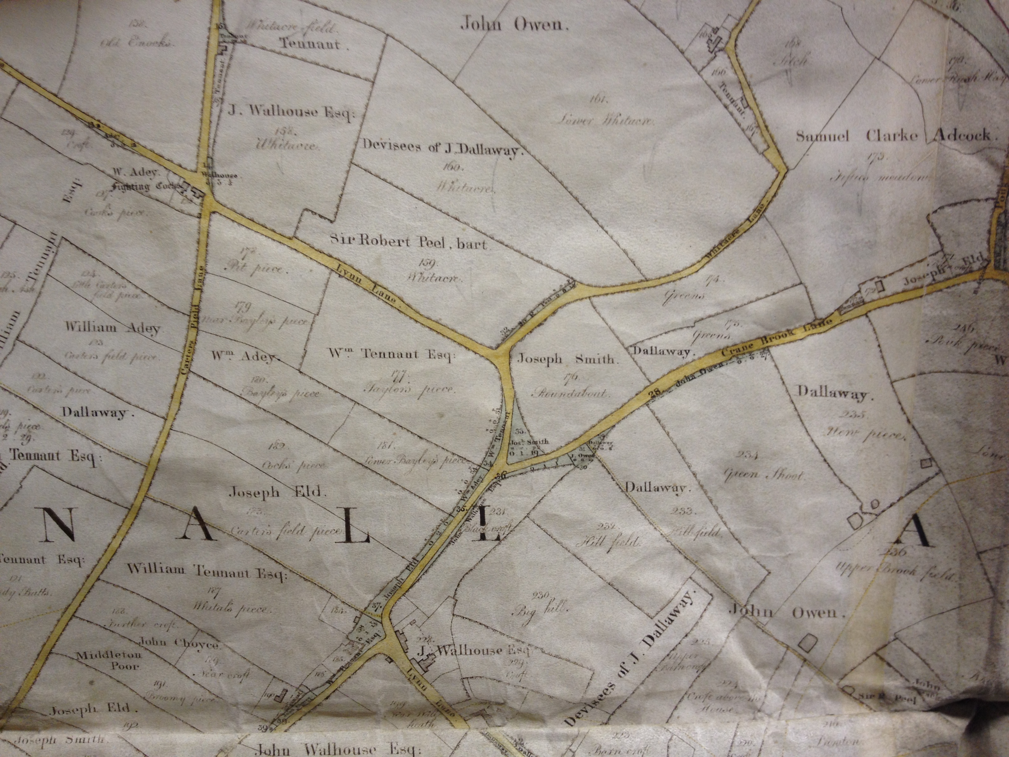
I just wanted to give a quick shout out for Lichfield District Council’s top Geographic Services officer, Gareth Thomas – Gareth, long time readers will recall, has shared loads of good stuff with readers of not just this blog, but others, including Lichfield Lore.
 Continue reading
Posted in Brownhills stuff, Chasewater, Churches, Clayhanger stuff, Environment, Fun stuff to see and do, Interesting photos, Local Blogs, Local History, Local media, News, planning, Shared media, Social Media, Spotted whilst browsing the web, Walsall community
Tagged Aerial photographs, Brownhills, Brownhills local history, Canal, Chasewater, Facebook, Gareth Thomas, Lichfield, local blogs, Local History, New Photos, Old maps, planning, Redevelopment, Shire Oak, Staffordshire, Stonnall, Things to do, Tithe Map, Twitter
14 Comments
 RSS - Posts