
Last weekend, I revisited for the first time in ages the subject that was once so prominent here – Chasewater dam – but not in reference to the recent renovations, but to the creation of the reservoir and the failure of the earthwork dam in 1799.

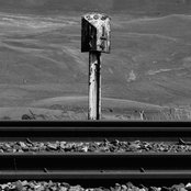
Although controversial, the Dam Works at Chasewater were nescessary to prevent a recurrence of 1799’s events. This line of earth and rubble is all that stands between the Crane Brook Valley and a deluge.
The necessity of draining and dam works that recently took place can be indicated by the following newspaper report, a remarkable snippet spotted by Peter “Pedro’ Cutler in the Staffordshire Advertiser of 15th June 1799. It describes briefly the effects of the dam failure in quite a graphic manner.
I’m interested in the location of Blackbrook – an if it was a place. The Black Brook is the name of the watercourse formed (I think) when the Crane Brook meets the Footherley Brook northeast of Shenstone. It goes on to flow through Weeford, Hints and on to the Tame near Tamworth. Where was the ‘New’ stone bridge?
I welcome any comment, or mail me: BrownhillsBob at Googlemail dot com. Thanks, as ever, to Peter for his eagle eyes. This really is a wonderful thing.

Spotted by Peter ‘Pedro’ Cutler, this clipping from the 15th June 1799 Staffordshire Advertiser. A great find, I think you’ll agree.
On Wednesday, the embankment of the reservoir of the Wyrley and Essington canal, on Cannock-heath gave way, and the water swept everything before it in the line it took through Shenstone, Hopwas, Drayton, &c. till it fell into, and overflowed the Tame at Tamworth. At Blackbrook, seven miles from the reservoir, the new stone bridge was blown up; numbers of sheep and some cattle were drowned; but two or three persons, aware of the accident, at the first, rode forward, and giving the farmers the alarm, they had time to remove the chief of the cattle and horses to high ground. The damage sustained is, however, very great and calculated at many thousand pounds. At Hammerwich, near Lichfield, the meadows are twelve inches deep with the gravel and water brought down with it.
 RSS - Posts


Cracking spot, Pedro!
The paper was published on Saturday, so the date of the breach was 12 June.
I imagine a stone bridge would have been expensive and important and wonder if the new stone bridge referred to was on the Lichfield – Birmingham turnpike road.
Great stuff. I would, however, remove the ‘translation’, partly because I doubt it’s needed, but also because it’s (uncharacteristically) riddled with errors, and you know what cut and paste can do for perpetuating these things across the interweb.
Hi Mick
Er, thanks. I was tired. I’ll endeavour to provide a better service in future.
The reason to transcribe is to make the text available to Google searches, which is why I generally don’t just post dry images of articles. Many hours are spent between me and contributors transcribing this stuff. I did that one via OCR and subsequently corrected it, but it was too late.
Cheers
Bob
Didn’t mean to ruffle your feathers Bob, I should have sent you a private message. Apologies, and you know well that I appreciate the efforts that you and everyone else involved puts into these articles.
Didn’t realise about the relevance to Google searches, good point.
Hi Mick
You haven’t ruffled my feathers at all.
I do try and get things right, but stuff written in non-natural language is always an issue to transcribe. I do welcome corrections always – but please point them out as you can’t see them in stuff you’ve typed yourself.
As a non typist, all this stuff is painful for me, which is why those who volunteer transcription are so appreciated.
Cheers
Bob
Hi Bob
I’d be happy to help out with a bit of transcription if you need any assistance.
Keep up the good work,
Pete
Pingback: The lost Howdles Lane dam | BrownhillsBob's Brownhills Blog