

Hot stuff? Where was Pepper Alley, exactly?
Here’s something I received yesterday from Hilary Little, the historian who helped reveal the lost history of the Royal Oak in Bullings Heath, Walsall Wood – this is sure to cause consternation amongst those amongst us researching the history of Walsall Wood.
For some years, there has been debate over where exactly Pepper Alley was. This lost road, lane or track is often mentioned in documents and news reports, but there is no longer a road in Walsall Wood existing under that name. It’s fairly clear that it was located somewhere in the Bullings Heath/Hall Lane area.
There is a theory that it was at the Lichfield Road end of Hall Lane, linking Hall Lane to the Lichfield Road, whilst others assert it was in the region of the Black Cock Bridge.
Hilary has unearthed something of great interest, that seems to nail it: it seems that the Royal Oak in Bullings Heath was at one time considered to be in Pepper Alley.
I am actually wondering if Hall Lane was once known by this name, although the two names do seem to have existed contemporaneously.
Comment is welcome: either here, or BrownhillsBob at Googlemail dot com. Cheers.
Hillary sent David Evans the following:
From the indenture between the Earl of Bradford and Joseph Wright and Charles Cliff Ashmore dated 31st March 1857:

Image kindly supplied by Hilary Little.
This indenture covers the parcel of land in blue:

Image kindly supplied by Hilary Little.
The said first Schedule containing a description of the said hereditaments and premises intended to be hereby conveyed.
All these three messuages tenements or dwelling houses adjoining each other with the yards, gardens and outbuildings thereto adjoining and belonging situate at Walsall Wood in the Parish of Walsall in the county of Stafford containing two roods and twenty perches or thereabouts bounded on or towards the North East. North West and and South West by lands of Mr Edmund Arblaster on or towards the South in part by premises of Joseph Lea and in other part by a roadway leading from Shelfield to or towards Bulling Heath. All which said messuages and premises hereby conveyed are now in the tenures or occupations of John Chamberlain, Joseph Thomas and Michael England.’
In the abstract of the title of Noah Cresswell to the Royal Oak Inn Walsall Wood dated 1905, there is a handwritten note relating to something in 1875 (a mortgage or similar) between H. Highway and Joseph Wright. The schedule pertians tothe following said premisses.
Three old cottages adjoining each other with the yard, gardens and outbuildings adjoining and belonging situate in Pepper Lane Walsall Wood.
Also three other dwelling houses one of which was a beerhouse called the Royal Oak which ? Dwg Hses were then in the respective occupations of Michael Ingby? and ots.
Note the address, left. Image kindly supplied by Hilary Little.
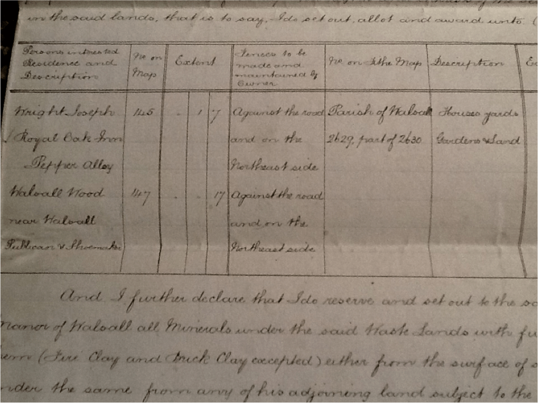
This is from a copy of an extract of the walsall wood inclosure award. Awarding two parcels of land 145 and 147 (Please see Caz’s map) to Joseph Wright who, it says, resides at Royal Oak Inn, Pepper Alley, Walsall Wood. This information is also in the abstract of Title for Noah Cresswell. It seems that Joseph sold the land in two parts, one to each of his sons in law, Noah Cresswell and Daniel Smith. Noah keeping the pub and Daniel having nos 4 and 6 Green Lane.
 RSS - Posts

Not sure, Bob.
Caz’s map provides an interesting lead via my ongoing collation of publicans into the 1871 census. John Critch was blacksmith and licensed victualler at the Black Cock Public House (as he was in 1861 and 1872 – PO Directory) and in 1881, retired blacksmith boarder at unnamed Beer House, Bullings Heath, head of household Joseph Wright.
The sequence in 1871 census is intriguing. Walsall Wood district 9, page 15
Shelfield Green Lane, 2 households (hh).
Pepper Alley 7 hh: Robinson, Parkes (both Pepper Alley in 1881), Aldridge (Bullings Heath 1881), Wigley (?), Bradbury, Matthew Cresswell (cont. p16), Joseph Lea (who on Caz’s map was behind plots 146-7.
Then the 2 pubs: Black Cock (above) and Royal Oak Public House, Joseph Wright, shoe maker and licensed victualler.
Then 2 more hh: Jones and Washington where the place name is [ditto] – Washington hh continued on next page (p17) with Pepper Alley named. Then Edmund Arblaster and 6 other hh ending Pepper Alley on p18. Next is Walsall Wood. In all 15 hh plus 2 pubs at Pepper Alley.
In 1881 most of these were recorded as Bullings Heath, with only 3 hh specified as Pepper Alley. Ref: Walsall Wood, Aldridge, dist 13, p6 et seq.
I suspect, then, that this is another example of migrating place names, possibly the result of enumerators not having consistent understanding of local nuances.
Hi Bob and gang…………..
It would be great to nail this one once and for all, the subject of Pepper Alley pops up every now and then and never seems to be completely settled. There has been discussion previously about it’s origins of name etc but it would be great just to know for sure where it actually was!
Good luck to everyone researching this one, the latest instalment as above is certainly putting forward some strong evidence, but it does seem that everyone is trying to hit a moving target on this one. Thanks to Hilary and the family.
Peter
In the 1861 census there is no mention of Pepper Alley, but that is probably a shortcoming of the census, rather than any suggestion that the name was not in use. There is nothing between Goblins Pit and Walsall Wood where John Critch and Joseph Wright as publicans and blacksmith / shoe maker, but without pub names.
In 1851 John Critch is recorded at Bullings Heath as a smith, but there are three neighbouring records for Pepper Alley (same as 1881? – names: Fox, Chamberlain, Harrison, not same). Walsall Foreign, Aldridge, dist 1b, p15. Only two other Bullings Heath; Roe and Corbett.
In 1841 there were also three records for Pepper Alley; Harrison, Chamberlain and John Critch, blacksmith. Next are Rowe and Corbett, Goblin’s Pit; Bullings Heath is not mentioned. Walsall, Aldridge, dist 5, p22-23.
From these it appears Pepper Alley lay between Goblin’s Pit and Black Cock Bridge / Hall Lane. The two pubs have both been listed as Pepper Alley and Bullings Heath and families Roe / Rowe and Corbett at Bullings Heath and Goblins Pit, so it is unclear from the censuses just where one begins and the others end.
Jne 1899…Water at Walsall Wood…SSW to be requested to extend their mains through Horobins Row to the front of Pepper Alley Bridge, through Hall Lane to Green Lane, and from Occupation Road down Hollanders Lane…This was carried
Feb 1901…Annual Sanitary Report…the water mains had been extended at Hollinders Lane, Salters Road, Pepper Alley, Occupation Road, Halls Lane and New Road, Walsall Wood.
Dec 1899…inquest at Black Cock in Walsall Wood, concerning death of Richard Richards of Pepper Alley…details given.
Nov 1884 a chainmaker of Walsall Wood was charged with various offences under the Debtors Act…he made no mention of possessing a house in Pepper Alley, Walsall Wood…
Sep 1885…the Inspector of Nuisances reported of overcrowding at Pepper Alley Walsall Wood. One family lived and slept in one room…
My ancestor was Richard Richards on the census he is listed as living in Hall Lane, Walsall Wood. The inquest was held at the Black Cock Pub. Would like to find out more.
Hi Lynn
I will send the clip to our Bob.
Thanks Pedro I will look out for it appearing on the blog.
I love the title “Inspector of Nusiances” I wonder what the job description called for?
Only find three mentions of Bullings Heath, and 1901, 1901, and the last 1903.
July 1908…Black Cock Walsall Wood Bowling team
Jan 1903…temporary transfer of the Black Cock, WW granted from Mr Jackson to Charles Gwilliam.
This is just a thought ?? My friend who lived in one of the 2 canal cottages in Hall Lane,has always told me Pepper Alley was opposite her house [where the double fronted cottage is now]. i was just looking back at the article that featured my Map and looking at the 1919 ordinance survey map, if you zoom in there does seem to be a road opposite those 2 houses, behind the Blackckock pub with 3? buildings maybe at the end of it. Could that be Pepper Alley ?
Hya Caz, I think you’re theory is worth checking out for sure. ” Three old cottages adjoining each other with the yard, gardens and outbuildings adjoining and belonging situate to in Pepper Lane Walsall Wood” Assuming the meanings of the words weren’t totally different back then would suggest to me that the 3 cottages were close by, next to, in the vicinity of Pepper Lane, Walsall Wood.
Although it also says that Joseph Wright resides at the Royal Oak Inn, Pepper Alley!
What about the un-named road on the same 1919 map that comes of Green Lane and leads up to the Royal Oak? Could that be Pepper Alley?
Peter.
Hi Pedro, the ssww item; Horobin row would be in what is now Camden st, then over the bridge now known as Black Cock Bridge but in the past could have been known as Pepper Alley Bridge, when you are over the bridge you have Hall Lane and Green Lane. So to me it looks like Pepper Alley is some where in Bulling Heath! as water mains pipes go in straight lines it makes sense to me!
This makes a lot of sense. The word “Alley” implies to me a narrow passage. Green Lane probably was just that; a narrow, rutted cart track serving farmland or common or heath in pre-enclosure times. There cannot have been much traffic serving the few houses west of the canal, though it must have warranted the expense of a bridge, but maybe there was only a narrow lane from what is now Camden Street over the canal (which we know was single track in our lifetime) and continuing to Bullings Heath and Goblins Pit, where it connected with the similarly narrow Green Lane. So maybe Pepper Alley Bridge was how people reached Pepper Alley, the lane to Goblins Pit.
Whether or not that is true, why “Pepper”?
This might be a daft question but what is the earliest reference we have to this part of Green Lane actually being called Green Lane?
David Evans tells me that Green Lane was used as the address for this area in the 1911 census…anyone got anything earlier?
An interesting question, Hilary! When did road names become important in addresses? Was this something to do with the growth of the postal service following introduction of the penny black postage stamp in 1840? Note that what is now formally known as Lichfield Road was referred to as Turnpike Road in censuses.
Pingback: Under the thatch | BrownhillsBob's Brownhills Blog
Pingback: Pepper ground | BrownhillsBob's Brownhills Blog
Pingback: Milking it | BrownhillsBob's Brownhills Blog
Pingback: In the club? | BrownhillsBob's Brownhills Blog
Pingback: One other Public Carriage Road or Highway | BrownhillsBob's Brownhills Blog
Hi I have a distant relative who lived in Pepper Alley and then the next census lived in Goblins Pit and I assumed they were very close.