

A remarkably clear picture of the demolition of the Clayhanger Bridge in I think, 1992. Image kindly supplied by Carrie Welvaert.
A quick one here for a Friday morning – a couple of wonderful pictures of the demolition prior to rebuilding of the Clayhanger Bridge, between the village and Lindon Road, Brownhills.
The pictures are remarkable, and will bring back many folks memories of just how steep and rickety the old bridge was – which I think was replaced in 1992. Is that really 25 years ago now?
Interesting to note the poor quality of the towpath and lack of trees on the still freshly landscaped Clayhanger Common.
The pictures were sent in by reader Carrie Welvaert who said:
I was looking through my late relatives photos and these were amongst them.
I know u often post pictures on the blog. I can’t remember it like this so was interesting for me to see…
Indeed – I remember well the bridge being like this, and how steep and perilous it was to cross – the slope of the Clayhanger side was murder when it was icy. I also remember there being traffic lights on the bridge for a while in the 1980s and there being a pedestrian footway next to it built out of scaffolding and wood.
Thanks to Carrie for some really interesting pictures, and if you have anything to add, please do – either by commenting here or mailing me: BrownhillsBob at Googlemail dot com. Cheers.

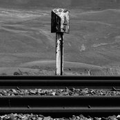
I’d forgotten just how poor the footpath was there. Image kindly supplied by Carrie Welvaert.
 RSS - Posts
I remmeber the old bridge well, cycling over it in the 80s to see a mate in Brownhills, and remember getting stopped by the traffic lights 🙁 .
Evene steeper than Black Cock Bridge, as I recall. Don’t remember the walkway, but it was a bit far for me to walk from Rushall.
I *think* I remember a date of 1994 on the new bridge, so that would put the demolition of the old one at 1992-3, I’d guess. Not 100% on that though.
I can remember them doing that I think early 70 we went walking one Christmas they had taken it all down. The new one is a lot better.
The old bridge was still there in 93 and the new bridge is dated 94.
I also remember how steep it used to be.
Driving over the bridge towards Clayhanger once I noticed a young girl cycling behind her dad on the left-hand side which was a bit of a dirt track beside the road. I thought – move over a bit just in case. The next thing that happened was that the girl built up a bit too much speed, started a wobble, hit the brakes and did a full 360-degree forward loop and landed in a heap still on the track and still hanging onto the bike. The girl got away with nothing more than a fright – but I wish dash-cams had been invented to prove that my eyes were not playing tricks!
That’s not a , it is a towing path, maintained in “first class” condition by the then British Waterways, obviously not helped by the activities the local vandals
I used the term towpath in the text and also footpath to avoid repetition.
As I recall in the 80s and 90s canal maintenance here was all but non-existent and in many paces the path had collapsed. Nice to see them take more care today,
Cheers
Bob
Sorry missed out thenword footpath
This was the bridge that my Great-aunt Lizzie Morris and next door my Dads cousins had their houses that sat below the level of the roadway Ihave many memories of visiting them there up until my teens when they were eventually rehoused. They still had no electricity and no flush toilets when they moved out about 1960..