

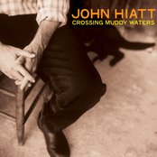
1921 1:10,000 Ordnance Survey map of the Brindley Heat and Cannock Chase, from the NLS archive. Click for a larger version. Click for a larger version.
Sorry folks some technical issues past couple of days so I’m running behind – apologies.
I’ve had an enquiry in from Charlie Hutton releasing to an bit of Cannock Chase I know nothing about – but in a bit of hunting around, it’s turned up an intriguing map and I have a feeling that readers on the Cannock side of the territory as well as fellow Chase-lovers may have stuff to say here.

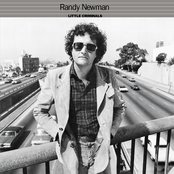
The White House is in a lonely spot on the corner of Penkridge Bank Road and Marquis Drive. Image from 1921 map above, sourced from NLS archive. Click for a larger version.
The White House stands on the junction of Marquis Drive and Penkridge Bank Road, and is a familiar landmark to anyone exploring this side of the chase.
Charlie wrote:
Hi Bob,
I’m working on a landscape project at The White House on the junction of Penkridge Bank Road and Marquis Drive on Cannock Chase. I would like to use the image to demonstrate the post-war afforestation as part of my report, but I’m wondering if it’s more of a OS copyright issue?
Do you have any further information about the pre-1980s building on this site, or indeed, any records of its demise in the fire? My remit is just to gather information about the White House and the surrounding area. I have details of the railway & WW1 camp but any additional or supplementary info or images that I could use would be incredibly helpful.
The purpose is to develop a more appropriate landscape/garden layout for the existing property. Its a prominent corner & steeped in so mush recent history so would be good to better integrate it into the surrounding environment. Any help or pointers appreciated! Email address below.
regards
Charlie
To answer the immediate question, I think you’d be OK and fair use applies here as regards the map.
I have no idea about the building at all – it seems to appear on 1:10,000 OS sheets of the area on the 1921 edition, and it may even have once been a pub (although that may be totally wrong). It’s latterly been a religious facility.

The White House as shown on Google Earth imagery.
I am sure, however, that I’ve seen old pictures of it somewhere, so if readers could help Charlie that would be wonderful.
I went diving into the mapping, and include the 1921 1:10,000 sheet from the NLS above – a better quality version can be perused here. What’s really snagged my attention is the Hospital – referred to on later mapping as ‘Brindley Village’ — what was that, and what do we know? I’ve a feeling I should know about that, but I don’t.
No visible trace of it seems to remain today.

The White House, Brindley Heath and RAF Hednesford (right) on 1947 1:25,000 mapping from the NLS archive. What’s Brindley Village all about then? Click for a larger version.
Anything you can help Charlie with (especially pictures would be great), or anything else on the general area, please do shout up – either comment here or Brownhills Bob at Googlemail dot com. Cheers, as ever.
 RSS - Posts


Brindley Village was latterly a community that was moved in the 1950s to the site of the original Tackeroo ‘hamlet’. Before it became a ‘squatted’ community it was part of the World War 1 military training camps of Cannock Chase. Specifically it was the hospital.
hi bob re the white house on the cannock chase for the past two years i have spent happy houers each afternoon re tracing routes and buildings from the first and second war years the source of my maps were from abook my late daughter gave me its title beeing A TOWN FOR FOUR WINTERS by cj and gp whitehouse in it are maps of what was and compatble photo graphs i also have a hand drawn map of brindley after the second world war when it became aplace for folk to live and names of folk who lived there perhaps some one has got copy to spare for our friend they dont want its got great maps and photos i treasure mine and walking made many friends god bless
just checked ther where two YMCA builngs near the white house listed as WMCAA ONE AND TWO one to the left and one to the right you can get a good cuppa at marquis drive ha ha
The Whitehouse is on the OS 1921/29 map but is not on the 1900/02 map. I worked there around 1984 for a few years and remember a chap called Jim who was into local history telling me it was an isolation ward house in the First World War, not too sure if I believe this. It seems to be on the Rugeley camp map, again I’m unsure
To the rear there was a tennis court, not sure if this was a real court of a hut base, in the 70’s I remember people playing tennis on the hut bases over the road on hut bases.
I would like to know when it was painted white; it’s called the white house 2 years after the war ended on a map.
I worked there from 1984 for Norman and Carmen Round. The restaurant had a white 70’s decor. The signature dish was fantastic paella which was served in a large paella dish and had dentist pliers to break open the crab claws.
A spooky thing happened one night, the Rounds had a young son; I seem to remember on night being asked to check the doors to the restaurant were locked. I checked them and came back to the kitchen and said they were all locked. When I asked why Norman said because his son had been talking to a soldier in the bar and he was an officer because he was dresses different to the other soldiers because of his uniform. Sometimes Soldiers from Fort Muller TA/Cadet camp near the rifle range. There was no one in there and when questioning the son and asking to describe the soldier he described the uniform of a First World War Soldier. Everyone was very spooked.
I was also told a story that one morning the beer pipes were being cleaned and someone who lived there who was an alcoholic game down stairs and grabbed a quick pint. Has they were half asleep and still drunk they downed most of it before they noticed; it killed them. Love to know if this was true.
Across the road not far there is a site called Gospel Oak on the parish boundary were in ancient times they would “beat the bounds”. Also across there was a trial pit shaft .There was a well there on some maps.
There used to be a lovely giant of a man called Pete I think who was one of the builders who helped build some of the new building. In spring he would tap the birch trees for their sap and make birch sap wine.
On evening the Woodcock would fly over calling. I hope they are still up there.
Some information about the hospital to be found at this link:
http://www.staffspasttrack.org.uk/exhibit/chasecamps/construct.htm
Hope it’s of interest, best regards.
If you know what you’re looking for, there are a lot of traces of the hospital still easily discovered. The base of a concrete pillar can be found with a small plaque denoting that was the entrance to the hospital. All around the area, concrete bases can be seen, in places forming the path.
The nurses quarters has one of clearest outlines still found. There you can find the concrete stumps with post holes guiding you along a short path to an area with a small earth ‘island’ (still standing well above the surrounding ground). From this ‘island’, the bases from the nurses quarters can be found, still barely touched by nature.
It’s a fascinating area to walk around finding traces of concrete floors, tarmac roads and in one area what looked like a tiled mosaic floor.