

Just where was Pepper Alley?
I have been sent this remarkable and incredibly thorough piece of research into the historical and mapping record for Pepper Alley by Hilary Little. Hilary, you’ll remember, was the driving force behind the project to record the history and fabric of the lost beer house, the Royal Oak, in Bullings Heath, Waslall Wood.
Here, Hilary adds a huge amount to the ongoing debate about the location of the mysterious Pepper Alley, which has puzzled local historians for many years. Everyone seems to have their own opinion as to where this long-gone thoroughfare existed, and as to exactly what the the name referred.
This article leads on from Hilary’s previous work on the subject, and also from David Evans surprising revelations about the involvement of the Street Family in the same area, which I posted last week.
I thank Hilary for a fantastic and very high quality piece of research, which I am proud and honoured to be able to post for readers. This is what local history is about – people looking at the place they love, and exploring the collective record together.
Hilary wrote:
Location of Pepper Alley – My Thoughts
This evidence is taken from four documents and the maps held within them and a couple of others from the blog.
The document I cite include:
- The Indenture which details the sale of a parcel of land to Joseph Wright in 1857
- The extract from the Inclosure award 1875
- The Abstract of the Title of Mr. Noah Cresswell to the Royal Oak Inn Walsall Wood, 1905 (he was the husband of Joseph’s daughter Emma). This was prepared as far as I can tell for the sale of the Inn to Lichfield Brewery
- The Abstract of the Title of Mrs. M A Smith to freehold property at Green Lane Walsall Wood in the County of Staff 1948 she was Joseph’s other daughter, Mary Ann and was married to Daniel. She had inherited the land from him upon his death and this abstract was prepared, when Mary Ann’s representatives sold no 4 and no 6 Green Lane to the council upon her death.
Both of these later documents tell the story of the splitting in two of the land owned by Joseph Wright in 1893 as it passes on to Noah and Daniel.
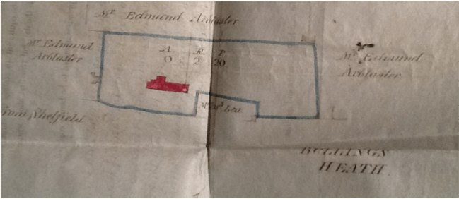
From the document of sale to Joseph Wright, 1857. Image kindly supplied by Hilary Little.
This is the plan taken from the document of Sale to Joseph Wright in 1857. The indenture says that Joseph Wright bought land and 3 cottages ‘adjoining each other with the yards, gardens and outbuildings thereto adjoining and belonging situate at Walsall Wood’ then in the occupation of ‘John Chamberlain, Joseph Thomas and Michael England.’ This would seem to be the buildings here in red.
A chunk of land owned by Joseph Lea is shown cutting into this area but the surrounding land is owned by Edmund Arblaster. The area is called Bullings Heath. There is no indication of what other houses exist here so do we have any map evidence from the wider area for this time?
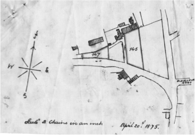
1875 plan. Image kindly supplied by Hilary Little.
This plan from 1875 outlines the two parcels of land awarded to Joseph Wright as detailed in an extract of Inclosure award… where Joseph Wright’s address is actually given as Pepper Alley.
Caz’s map shows more detail of the surrounding area:
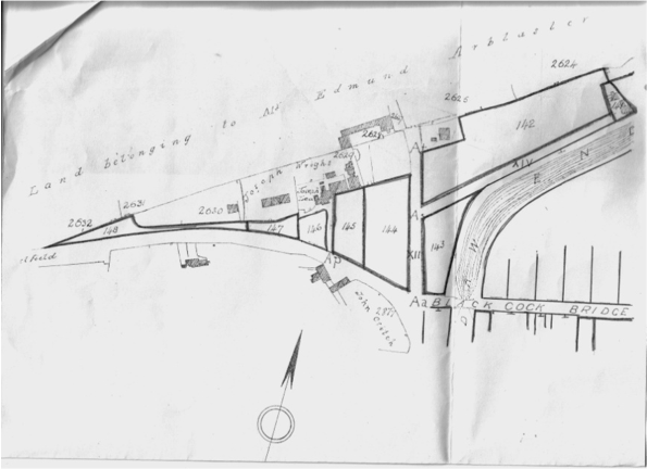
Image kindly supplied by reader Caz.
This again dates from the same time frame and appears to refer to the same inclosure award.
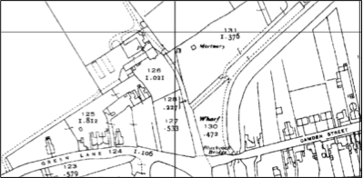
Inclossure awar map detail, as supplied by reader [Howmuch?].
Above is an extract from a map sent to the blog by Howmuch for the Inclosure award and dated 1876, so just a year later than above.
This shows the land owned by Edmund Arblaster, Joseph Wright, John Critch, George Street, Sarah Marlow and George Boot up by the canal. Evidence of Joseph Lea’s land is not apparent here but you can see the buildings and evidence exists before and after this map.
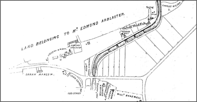
1888 Ordnance 1:2,500 Survey map of the area.
This map shows the area around Hall Lane in 1888, after George Street’s house. From David’s evidence we can put George Twist in the house owned by George Street and in 1871 he appears on the census as the last house in Bullings Heath before Hall Lane.
These maps show a number of access ways…
- The main road which appears to veer round into Hall Lane as well as going up and over the bridge. There is no evidence as to what this road was called although we now know it as Green Lane.
- A route to to Arblaster’s farm which forks out to the property owned by George Boot alongside the canal.
- A further route serving the old cottages from 1857, and a growing community of newer houses with the new Royal Oak, its next door neighbours and also, a house marked as being Joseph Lea’s house on the other side (which may have been there in 1857… We don’t know yet).
- A route next to the house owned by George Street which looks like it goes down to some cottages behind the Black Cock.
Can anyone suggest any others? If not then, as we have references to several homes in this area as being in Pepper Alley/Lane is it safe to say that this address must exist somewhere in this small area?
To get a bit more information about Joseph Lea’s whereabouts, lets leap forward a little to 1893. The plan below shows more clearly what land belonged to Joseph Wright and what belonged to Joseph Lea at this time.
(Incidentally, the plan was drawn up to mark the entitlements of Joseph’s Wright’s two sons in law, Noah Cresswell and Daniel Smith when the land was split up in 1893.)
Joseph Wright owned all the land outlined above except for the bit in the middle which was owned by Joseph Lea. We know that some of this land was owned by Lea back in 1857 although the extent of it and what was built on it is not recorded on the map of that time.
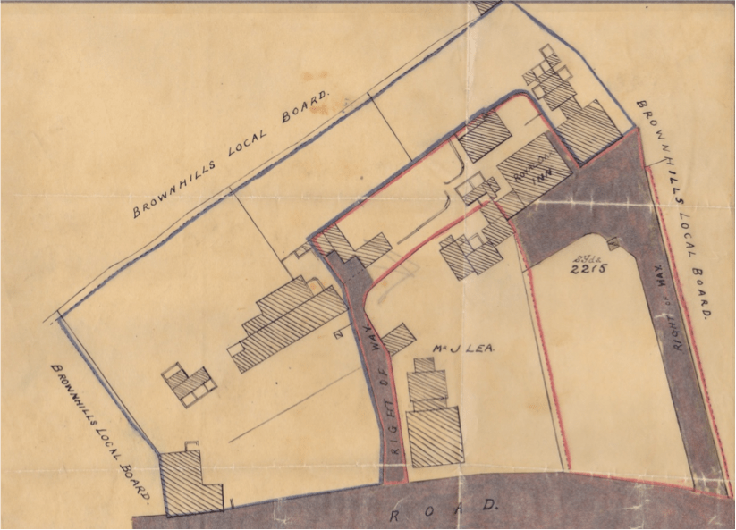
Wright’s 1893 plan marking the entitlements of his sons-in-law. Image supplied by Hilary Little.
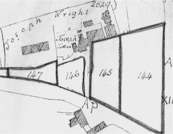
Now another question – what was the purpose to the inclosure act and how did it affect the land ownership of the area? We know that Joseph Wright was awarded parcels of land identified as 145 and 147 on the Extract of inclosure award.
Does it makes sense, to suggest that Lea’s land would have grown in the same way as Wright’s by obtaining land parcel number 146 in the Inclosure award? If so, both of these landowners now own land that fronts on to the road we know as Green Lane.
While this map shows a house built on to Green Lane labelled Mr. J. Lea, we know he lived here before this house was built as he appears on the 1871 census. If we look at both Caz’s map and the above map, there is a collection of buildings (ringed in the plan above) which, although they look joined to the Royal Oak, they are clearly not built on land owned by Joseph Wright. I suspect that this was where Lea lived in 1871.
Extract from plan supplied by reader Caz.
So, going back to Caz’s map of 1875 you have a little community all set back off the road, separated from the road (Green Lane) by common land down a little path way.
Remember at this time Joseph Wrights address is given as ‘Royal Oak Inn, Pepper Alley’.
Does this evidence point to Pepper Alley being the lane down which all these houses were accessed?
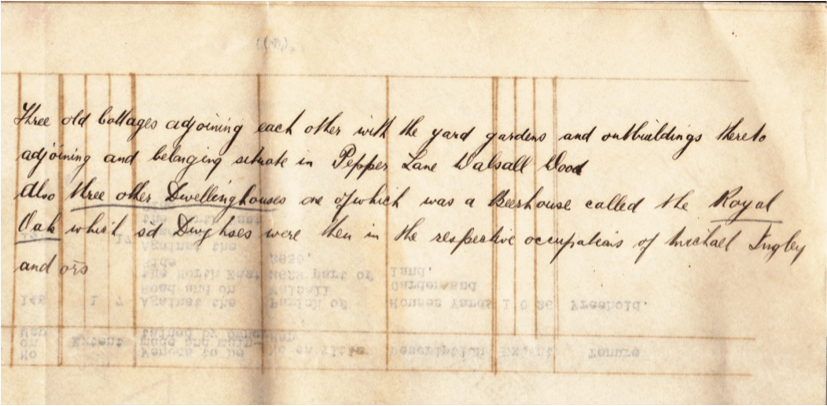
As further evidence, there is a reference to Pepper Lane (rather than Alley) which records an agreement between Joseph Wright and H. Highway (it is unclear whether this dates from 1860 or 1875, but it appears in the abstract of Title for Noah Cresswell. I think this reference refers to the whole plot of land owned by Joseph Wright at that time and describes it thus:
’Three old cottages adjoining each other with the yard, gardens and outbuildings adjoining and belonging situate in Pepper Lane Walsall Wood.
‘Also three other dwelling houses one of which was a beerhouse called the Royal Oak which said dwelling houses were then in the respective occupations of Michael Ingby? and others.’
(At least I think that’s what it says – can anyone clarify that?)
Agreement between Joseph Wright and H. Highway, date unclear. Image supplied by Hilary Little.
The three old cottages mentioned here would seem to be the ones that were in existence in all the above maps from 1857 up to 1893, the pub and the house next door to the Royal Oak we know was ‘semi-detached’, so that description fits with the map evidence.
In 1893, when the land is shared between the two sons-in-law, the land outlined in blue (which became Daniel Smith’s land) on the above plan dated 1893, a funny kind of C-shaped plot, contained these cottages and (according to the abstract of title of Mrs. Mary Ann Smith), was described thus:
‘Land conting 3075 sq yds… Six messuages or tenements… One of which fronts to sd road and in the occpn of Francis Ball… Three other houses stand back on said land and in the respective occupations of Matthew Cresswell, Wm Pincher and James Parker’
That was, I think, the three old cottages. Further:
‘…And the other two of the said houses were near to a beerhouse called the Royal Oak Inn and were in the respective occupations of James Harries and William Amos’
Probably the semis that later became known as no 4 and no 6 Green Lane?
Again the description fits with the map evidence, and pretty much pinpoints where these people from the 1891 census lived – of course lodgers, sub letters etc. I can’t account for.
Curiously also by 1893, new access arrangements have been created in that there are now two rights of way serving the properties, neither of them in quite the same place as the original access way. I do believe this is still marked on the 1893 map as it represents the border between land that became Noah Cresswells (marked in red), and Joseph Lea’s land.
[Bob’s note: This is true, they do appear to move a little. I was confounded by this movement when overlaying mapping onto Google Earth a couple of years ago, and dismissed it as a drafting error. I clearly wasn’t.]
After 1893, yet more houses were built on land formerly owned by Joseph Wright including those which fronted on to Green Lane as shown in the 1938 map.
1938 Ordnance Survey 1:2,500 map of Ppper Alley and Bullings Heath.
Interestingly, in the newer conveyance documents for the old pub – that is, the one recording its sale to George Powell by Lichfield Brewery in 1936 – it talks about ‘the road leading from Walsall to Brownhills now known as Green Lane, Walsall Wood, ’ which rather suggests that this road was previously not known as Green Lane at this point on its route.
What about the evidence for the route way in Hall Lane itself being Pepper Alley? Well notwithstanding the fact that this would mean that the Extract from the Inclosure Act giving the address of Joseph Wright was wrong, what evidence exists? Are there enough houses here to explain the number of references that exist for Pepper Alley?
A lot of conjecture here but is it possible that what started off as Pepper Alley, grew to encompass the whole area, including perhaps the area just in Hall Lane. Maybe that meant that it needed to take on a more fitting name and thus it became known to some as Pepper Lane?
 RSS - Posts


Great detective work Hilary, well done to you and all that have supplied info for the project.
HI Bob
It might be useful to try to determine why the name “Pepper Alley” came about for this settlement. Routledge Dictionary of Historical Slang defines “Pepper Alley” as .”.rough treatment, hard punching as in Sporting Magazine 1820..pugilistic” (This seems to predate the Royal Oak beerhouse here.).
Did the name “Pepper Alley” reflect this activity , and/ or the place where it occured?.
We know that a Mr George Birch lived there..and was a(horse?) shoe maker there. (1841 census.Staffs/Walsall/Aldridge/District/page 9 of 9)..before Mr Joseph lea, awl maker, appears, in the 1851 census.
So, perhaps,sporting or non-sporting fisticuffs or “rough treatment” /conflict among bargee customers who needed to have their horses shoed.quickly ( time is money) ? ..
Thank you, Hilary for your super investigation.I think it has got us all thinking!
and a big thank you to Bob, for the excellent presentation
kind regards
David
,
I wondered if it might be Michael Dingley, a Walsall Wood surname; alternatively, the death of a Michael Ingley, aged 47, is recorded at Walsall in 1866.
Hi John, it could well be this Michael Ingley. On looking more closely at the document, his name is mentioned in the indenture dated May 1860. It appears to be for a loan from Henry Highway for £400 where the above dwellings are listed on the indenture schedule. I’m assuming this means that they are the security for the loan, please let me know if I have got that wrong. Thanks for the information, was there any address information in this record?
Hello Hilary, I found the name Michael Ingley almost by chance on Free BMD after I’d failed to turn up any record of a Dingley. The site tells you how to order a copy of the death certificate, which should give you an address, an occupation and the name of the informant.
Thanks to everyone involved with this, i love to learn about the history of the area.
Thanks Bob for all your hard work with transcribing “my thoughts”, you have done a fantastic job. Wouldn’t it be marvellous if this article generates lots of discussion and debate, with readers of the blog adding their own piece of the jigsaw. I think more information on the land owned by Joseph Lea would be useful, so that we can find out what buildings might have been there in 1857. The buildings shown in 1875, were still there on the 1919 map but by the 40’s were a pile of rubble in the garden of the Cox family. I’m also looking for evidence of the cottage that would have been between no 28 Green Lane and the old no 24 where Mr Pierce lived. My uncle Ron thinks this was demolished sometime in the 30’s. That fits with the mapping record as it is present on the 1919 map but not on the 1938 one. Anyone got any more information?
Hello John and Hilary, i think you have hit the nail on the head, if we can find someone whose death occured at a building we think is in Pepper alley. Then the the address should be on the death certificate!
Hi Clive, Thanks for your reply, from the indenture, I would put Ingley in one of the houses next door to the Royal Oak… between it and the farm….what later become no 4 and 6 Green Lane. These houses didn’t exist before 1858 and so wouldn’t be the original “Pepper Alley” but it would give us confirmation as to whether they were considered to be Pepper Alley in 1866. In turn, this would then corroborate the census of 1871 which, by the looks of things, seems to put all the houses in this area in Pepper Alley ..or not as the case may be.
Hi John, re Michael Ingley; I think I have just found him on the 1861 census, (big thanks to David Evans). This census doesn’t (as far as I can tell) mention Pepper Alley as such, just Walsall Wood. Both David and I thought the name was Langley originally, but the age fits, he was 41 in 1861 and living with his wife and 5 children aged between 2 and 14. Sounds like there could be a tragic story here, if he did die just 5 years later.
Hi everyone.
i’ve been talking to a friend tonight who lived in one of the ‘canal’ houses in Hall Lane for many years. She told me the Twist family lived in the end cottage , far left, in the row of 4, as you look from the road in Hall Lane.[ looking on google maps it’s no 141]. She married a lovely man, who was born in Bullings Heath, and lived there his entire life. She is convinced Pepper ‘Pot’ Alley [as she called it] is the track marked opposite her old home,running behind the Blackcock Pub and leading down to what is now Oakwood Close. She did tell me the names of other people living in both the Hall Lane cottages and those who lived in the cottages in Green Lane, but sorry, my memory fails me, i shoud have taken pen and paper. One i think was Beddows ? She does have some Maps of the area that belonged to her late husband and she is going to have a look to see if Pepper Alley is marked on any of them.I can’t see it listed on any of the maps i have .
Hi Caz, it would be really interesting to look at what buildings were along this track in the time frame that Pepper Alley was known to exist. I’m particularly interested in the earlier dates, prior to the 1871 census (as this puts pepper alley as the name of the settlement at the top of the page of entries).
I’m sure Bob will agree, but I think any mapping from this time…or anything as clear as your indenture map would be of great interest to the discussion. Do you have any further info about the original history of your house or the land that it sits on, that might help, names of original owners etc, I am presuming rather cheekily that you live in Green Lane…….I’ll do a complete list of the families who lived in the Lane in the forties when I get back from work later on.
Working together, perhaps, we can solve this mystery once and for all.
Hi Hillary, yes you’re right, i do live in Green Lane and with all these big house they keep building around us, ours looks smaller by the day lol.i think it was a Mrs Jones who lived in my house and Mrs Bott in the one next door, although we actually bought the house from Walsall Council.i’ve gone through my deeds to see if i can find anything and i have sent Bob a couple more plans that i have but they aren’t dated, so not sure if they are of any use.Maybe someone can date them from the houses marked [Bob, i’ve actually now found the date 1975 on the land registry plan. i thought that the cottages,nos 14-22,built either side of the right of way to the now demolished Pub/Smith family home were demolished before that date? obviously not] There are references to an ‘indenture made the 31st may 1855 between Earl of Bradford and Edmund Arblaster’ and extracts from the Inclosure award 7th May 1876 [ the original plan i sent Bob is connected to this and dated 26th february 1879 and signed by a Matt Blakiston ? clerk of the Peace] there are extracts from a conveyance dated 19th april 1939, made between urban district council of Brownhills first part and Llewellyn Jones, Alfred Shaw and Arthur Davis of the second part, and Walsall Wood colliery Company Ltd of the third part. I can’t find reference to any other names of people having lived in my house previously. i remember chatting to an elderly man many years ago, walking his dog on Oak park and living in Occupation Road, who told me he had lived in my house as a child and it made me wonder about the people who’d lived or died here in the past…we haven’t bumped into any ghosts yet lol. If you have any info on any past residents i’d love to hear about them. Thanks for all your info about the area, it’s really interesting to hear about. Best wishes Caz
Wow…that’s marvellous, Caz. There must be something in your deeds for number 26, which may have been demolished in the 1930s.
Next up the lane from your house was a detached, double fronted house with a pathway at the side of it. This was number 24 and my mum was born there in 1937 before her family moved into No 8 (the royal oak). More latterly the Pierce family lived there before it was demolished in the mid 70s. Mr Pierce would stand at the gate and watch the world go by, I think his wife suffered from dementia in her later years. Next there was a terrace of 3 cottages, the Kempson family lived at no 22, followed by the Hood family at No 20. No 18 was the Richards family. I think these were demolished not long after the current no 10, 12 and12a were built. After the back drive, was the Humphries family followed by the Cox family, they lived in the pair of houses built on Joseph Lea’s land. Mrs Cox’s side garden was the home of her sons caravan before the land was used to build the detached house at number 12a. Then come the pair of semis, numbers 12 and 10 ( think) which were built on land sold to Mr Till in 1963 by my Nan to pay for Aunty Jenny’s wedding. Incidentally, it would be great to find out whether that pile of bricks at the bottom of Mrs Cox’s Garden was the remains of the old nos 12 and 10! Next came the Royal Oak, after the brewery sold the pub to George Powell in 1936, he subdivided it into 2 houses.The Beddows family you mentioned lived on the side furthest from the canal at no 8, my nan and grandad originally rented half of the house before buying the whole thing in 1950. Their address was 8a. Just a few feet from them were no 6 and 4. In the forties, they were home to the Tappington-Walkers followed by the Goring family and more recently the Locket family (hello, Aunty Lil if you’re reading this). Grandad bought these houses from the council in 1958 for £35 on the condition that he demolished them. Then comes the farmhouse. The only other houses in the lane, apart from the Black Cock, were 3 terraced cottages. They were home to another Hood family, the Pallatina family and the Nutting family. These cottages look like they could be the ones labelled Sarah Marlowe on the indenture map of 1876 and were demolished in the late fifties, according to Mom. I personally, of course am far too young to remember all this, but I’m sure mom will correct me if I’ve got any of it wrong!
Forgot the Daniels in the farmhouse and Mr Marklew in the house up by the side of the canal…..thanks mom
Thanks Hillary, I feel like i’m being transported back in time and picturing things as they were.Does your Mom remember anyone who lived in my house and if so what were they like? i can’t find any mention of a no 26, but when we brought the house their was no 26.The next door neighbours were no24.and our house had an absolutely massive garden, which unfortunately we didn’t get lol we were told at the time [1984] that the land would be divided and sold at a later date to the highest tender. My dream was to win the lotto so i could buy it myself when the time came, unfortunately i didn’t.Luckily i have some wonderful neighbours. When the land did go up for sale we received a pack informing us that the land up the road would also be for sale once the ‘right of way access’ [to your Mom/ Stans house] was resolved. I remember as a child coming to play hide n seek in the coppy woods and must have walked past my house loads of times but i can’t remember it or what Green Lane was like at all, yet i remember walking past old terraced houses in Camden Street. Best wishes Caz
Hi Caz, mom said she will have a think about who lived in your house before Mrs Jones, she will remember, it just takes something to trigger it off. I remember there being a huge garden to the side of your house. It would be interesting to find out when Green Lane became Green Lane and the houses were given their numbers. it must have been around the turn of the century, as this would have been when nos 18,20,22,28 and 30 were built.
Thank your Mom for me. i wish whoever came up with the name Green Lane, had thought of something a bit more original, then maybe my parcels wouldn’t go astray lol
Hi Bob
My ancestor Richard Richards lived at Pepper Alley in Walsall Wood before he died in 1899 an inquest was held at the Black Cock Inn concerning the events of his death. His niece Mary Birch looked after him at her house in Black Cock Road. I have search the 1901 census for John & Mary Birch they lived near the sewage farm then there were 3 addresses listed as Bullings Heath then the Royal Oak Inn (Noah Cresswell) then another 12 addresses then the Black Cock Inn (William Jackson) then Pepper Alley:-
Households in Pepper Alley from 1901 census
Richard Baton born in 1839 from London and his wife Ann born in 1837 from Walsall Wood.
James Bate born in 1834 from Walsall Wood his wife Ann Bate born in 1848 from Warwickshire and their son John Bate born in 1879 from Walsall Wood.
Hiram Corbett born in 1878 from Pelsall his wife Jane Corbett born in 1883 from Walsall Wood and their daughter Clara born in 1900 from Walsall Wood.
George Corbett born in 1876 from Bloxwich his wife Phoebe born in 1880 from Walsall Wood and their daughters Hannah born in 1899 from Walsall Wood and Ada born in 1900 from Walsall Wood.
Next listed on the census is Hall Lane with 4 properties with the families Twist, Dixon, Walths and Birch the next property is the Dairy Farm in Hall Lane with Thomas Sheldon as the head of the household followed by other Hall Lane properties.
My ancestor Richard Richards is listed on the 1891 census as living in Hall Lane so I don’t know if he moved to Pepper Alley or if the part of Hall Lane he lived in was part of it.
He appeared to be a troublemaker in trouble with the police for drunk, disorderly and fighting. He appears in the Petty Court Sessions in the local paper.
Apologies for errors on census writing is unreadable in parts.
Regards Lynn
Thanks Lynn,you jogged my memory….i’m pretty sure Birch was one of the names my friend said lived in the row by the Twist family. The Twist family had a daughter Pam, if i’m remembering correctly.
I wonder if the Twist family moved into and out of Hall Lane several times. My mom was at school with a Dorothy Twist who lived in one of those cottages near to Mrs Tooth’s shop…the last one of the four, but she seems to think they only moved in there sometime in the late forties, when she was in secondary school. She also remembers that Noah and Dennis Stokes lived in the one closest to the shop and the Craddock family lived in one of the middle two.
She also remembers A Richards family, much later than the one you mention, they lived at number 18 Green Lane. The “children” of the family would all be in there 80s and 90s now but were called Sid, Hettie and Brenda and one other she can’t remember. Is this a different Richards family?
Do you know the Anslow family who lived around that area. The other side of my family were the Bentons who ran Ryders Hayes Farm.
We lived close by to a Mr Anslow who lived in the double fronted house in Camden Street, he was a builder I think. Part of his back garden was used to build the latter part of Barns Close. Is that the same family?
My Gr Grandad was William Anslow born 1888 Walsall Wood my Gran remembers an Anslow family in the big house in Camden Street but not sure how they were related and she never asked but I would love to find out more. What year are we talking about? My family moved from the old part of Walsall Wood in 1950’s to the new estate off Streets Corner well it was new in the 1950/60’s.
We moved into Barns Close in 1970 and as far as I can remember he lived there then.
That would have been Jimmy Anslow, my grandfather’s cousin and a carpenter by trade.
HI Hilary
a fascinating developing topic! A quick look..on the front page of the blog; Sue Lote’s Walsall foreign/WalsallWood/Moseley dole 1801….There is a widow, Mrs Street claiming 2d = two people.. seemingly in “Goblins Pit”….but no Pepper Alley, well, not in the part of the dole document that has been included in Sue Lote’s article.
cheers
David
Hi David, gets quite addictive doesn’t it. I’ve been trying to find out a bit about John Chamberlain, he is the only name that seems consistently in Pepper Alley in those earlier times. He is mentioned as being there in the deeds, and in the 1851 census. Andy Dennis’s note on Pepper Source also says he is there in 1841. I have found a reference to the baptism of his two sons in 1837 at St Mary the Virgin in Aldridge on Sue’s web site. This gives his residence as Walsall Wood and his occupation as a miner…..but that’s as far as I’ve got.
Pingback: A public partnership | BrownhillsBob's Brownhills Blog
Caz, mom and Ron have dug deep and come up with the name of Donald Jackson as the boy who lived in your house, he was the same age as Mom’s sister Joan (about 82 now). However, mom thinks it is far more likely that you spoke to Michael Hood who lived with his Grandad at no 20. He stayed local…Occupation Road, she thinks….and loved to chat!
Hi Hilary, Thank Val and Ron for me. The man i chatted to had a black and white collie dog, at the time, deceased by now and i think he lived in one of the houses just off Brownhills Road. best wishes Caz
Any one got any information about the cottages behind the Black Cock? When mom was small, there was a bungalow there, owned by Arthur Till, the builder who built the current no 10 and 12 Green Lane. Mom says ” it was a posh house” and accessed down the driveway from Hall Lane. My guess is that Arthur built that bungalow on the land where those cottages were. Two of his children still live in the vicinity,
Both me and my brother still reside in Oakwood Close, we are Mr Tills children. The bungalow down the driveway was 151 Hall Lane and owned by my fathers parents. On there death dad purchased it, this driveway in between the Black Cock Pub and the shop in Hall lane was called Pepper Alley, despite the postal address being Hall Lane. Later on Dad purchased land from the Black Cock (brewery) knocked down the bungalow and developed what is now Oakwood Close. The first house in Oakwood close was the pubs bowling green.
Hi Joan, that it interesting, thank you for posting. Do you have any idea when your grandparents house was built?
Regards
More information about the area in the 1960’s onwards and the families who lived there. The Black Cock Inn was ran by Ray Holland for a while his mom Daisy Holland lived nearby last house on the left. Not sure if this house and the pub are owned by the same people. The pub Landlord was then Ken Hodges I’m sure everybody knows him. Mr Coleman had a house by the Black Cock where sold horse brasses I believe he had a factory in Walsall called Colemans. My mom remembers Sid Richards and Jim Price living in the double fronted houses opposite the pub next to them was Jim Kempston, George & Nancy Mole and another family in a terrace row of 3. She also remembers Mrs Bot and next door to Mr Whitehouse who lived in the last two double fronted houses on other side from Black Cock. Joe Beddow also fits in somewhere.
I hope this makes sense without double checking with census records which is of course not available yet.
My uncle’s brother a Mr Greatrex built the 2 big detached houses in the late 1990’s.
Pingback: In the club? | BrownhillsBob's Brownhills Blog
Pingback: What was lost, now restored | BrownhillsBob's Brownhills Blog
Pingback: Within and without | BrownhillsBob's Brownhills Blog
Really interesting. Many thanks for your research. In researching my husbands family tree, I have found that his 4 times great grandfather, Joseph Peakman, died at 87 Pepper Lane Walsall in 1872, which makes it look as though there were quite a few houses there at that time.
Hi Christine
Thanks for the post. Can I ask you whether Joseph’s daughter Harriet, married George Boot? We can place where George Boot lived in 1871 as his house is plotted on the small inclosure map of that year. The census of that year puts Joseph Peakman and his wife, living with their son in law….but with the handwriting of the time, the surname is a little difficult to read…and looks like Bloot. The curious thing is that in the census, that address is given as Canalside.
That does fit with a theory that in 1871….the whole Hamlet was called Pepper Alley.
Regards
Hilary