
Here’s some mapping I’ve been meaning to run since reader Peter mentioned it in the comments to the post ‘Keep out of Cotterill’s road‘ on Friday last. I may have posted similar before, but if I have, I can’t find a copy.
In that post, there’s a fragment of map which historian Gerald Reece found back in the 1990s when researching his book ‘Brownhills A walk into history’. The map section is from the first large mapping carried out by the Ordnance Survey, whose date is argued hotly and shows clear variance across the countrywide plot. Of course, this is to be expected, as the project was huge and would have taken years to complete.
Gerald pointed out that the map of Ogley Hay predated Inclosure and showed the pre-Cotterill road system. This mapping is now accessible in digital form, and I’ve used sections of it before, notably in my post about Goblin’s Pit. Since Peter was so interested, I thought I’d go for a wider area so there would be plenty of interest.
In answer to the specific questions, as fellow reader Clive points out, the Tonnage House was the toll point on the canal, where boats were gauged for weight and charged accordingly. A later (or possibly the same!) incarnation of it is shown in this post on the Black Cock Bridge; I think it’s the hut the bicycle is leaning against behind Alf Mole and his workmates.
The Machine House is a mystery, but as this was the time of shallow mining on the common nearby, I suspect it was a pumping engine.
Take a long look at this map; it shows how names evolve and disappear. It’s a beautiful thing.
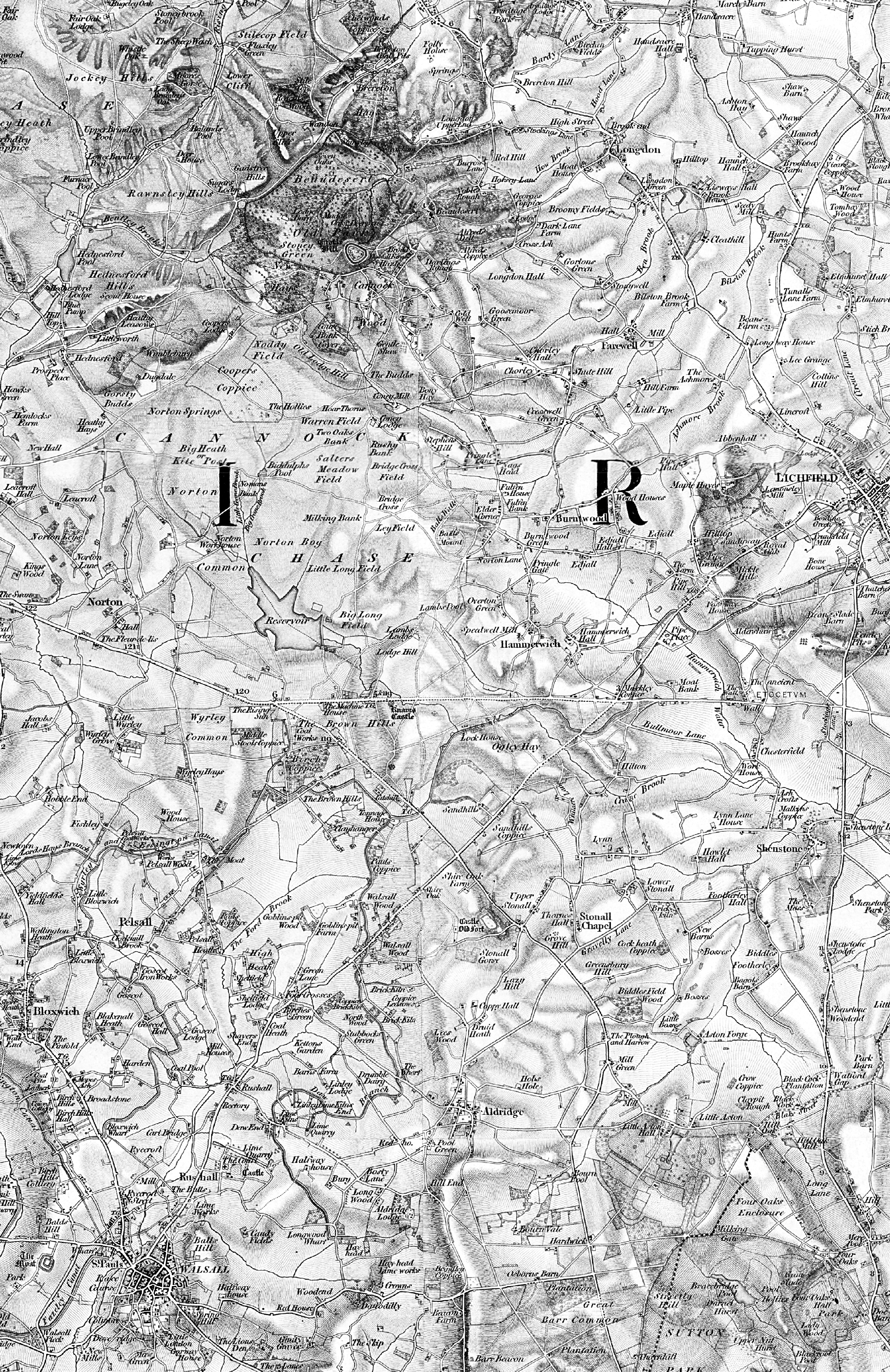
This is about 1:50,000, and is the first Ornance Survey mapping of our area produced. As Gerald Reece points out, it predates the 1938 Inclosure of Brownhills. Click for a much larger version – it’s a very big image, so please be patient.
 RSS - Posts


I notice that the canal from Chasewater does not follow it’s existing route, either the map is not accurate or the canal was re-routed. Also what is the ‘The Mudune House’
Hi Dave
The Anglesey Branch – linking to the W&E at Ogley Junction – only existed as a connecting channel until 1850 (as it’s shown on the map). It was later rebuilt and upgraded to a navigable canal. The map is accurate in that respect.
The Madune House is the Machine House as referred above, and remains a bi of a mystery.
Cheers
Bob
Hi, thanks for posting this lovely map, is there a version of it online showing more of the Lichfield/Whittington area?
I shall do a version for lichfield for you. Barry points out a source below, but I’ll do a large one, no problem.
My source is a professional map service.
Bob
Fantastic – thank you very much! It’s fascinating looking at these old maps especially comparing them with modern day satellite imagery. It’s really interesting fseeing old features/buildings/roads which were there 100 years ago, and then finding the remnants on Google Earth in places you never realised there was history, often just around the corner!
Mike
Hi Bob
A super map…many thanks for posting it….and for the other info…
Kind regards
David
Thanks, Bob. This is really helpful. I’ll do more on this as I think I see an answer to a question I’ve had for years.
Anyway, I have a paper copy of this. I did try to scan some of it, but the folds and gaps – it’s in four panels – was a limited success.
The copy I have was published by David & Charles as Sheet No. 42, Lichfield (Birmingham and the Black Country) – Reprint of the first edition of the one-inch Ordnance Survey of England and Wales. Undated.
The small print on the map sheet says it was originally sheet No. 62 and published in 1834. The survey work seems to have been carried out for this sheet in 1831-1832, though the first field surveys were for 1814-1817. The scale is one inch to the mile or 1:63,360.
My recollection is that there is some variation from the current national grid so that overlays caused considerable distortion, but I will have another go at this later. The weather is too good to be stuck inside.
Actually it’s a good fit with modern 1:50k mapping.
The source is a professional map server service you’d probably be familiar with. I shan’t name it for obvious reasons.
This mapping has theoretically been geometry corrected to match the national grid at 1:50,000; however, I also have the sheet copies you have, and found the photo resizing of them to be very grim. The correction in this is sloppy in places, and there are a few tears, but it’s not bad at all considering the 180 year gap and lack of solid relativism in the survey. Looking at it from a purely logistic point of view, making this mapping was a mammoth, remarkable task.
Thanks for the added info.
Maps are beautiful, in the OS we have the best in the world. This mapping is a lovely stepping stone from the Yates Map and it’s ilk to the new popular editions tat came later.
Cheers
Bob
An online version that covers the country can be found here. http://www.visionofbritain.org.uk/maps/results.jsp?xCenter=3162500&yCenter=3175000&scale=63360&mapLayer=nineteenth&subLayer=first_edition&title=Ordnance Survey-1st Series
Thanks Barry 🙂
Thanks Barry, and also to Bob.
I had come to this site before but somehow passed over the mapping.
All the best Peter
Great map Bob, thank you.
Where was the timber growing?
There was an auction of a huge amount of timber in 1796 at the house of Mr Robert Hanbury, the Fleur-de-lis, at Norton under Cannock, Monday 23 day of January…to be sold by auction.
The timber is marked and numbered, growing in the parish of Norton under Cannock…close to the canal which goes from that place to Wolverhampton, five miles from Walsall, and near to good turnpike roads.
Sounds like Pelsall to me.
Anyone any ideas? I’ll post the ad later in the week…
Cheers
Bob
This rings a bell. It maybe King Hays farm or Goblin pit wood, i have read this some were! i will see if i can find the info.
Hi Bob
1772 small ads. A bit of help please. Article may show the reference to timber….it’s part of the goblins Pit discussions, as Clive spotted
Cheers, Clive
David
http://brownhillsbob.com/2012/03/18/1772-small-ads-a-bit-of-help-please/
Lot of frogs in this huge woodpile…
Enjoy
Bob
But no “escaped slaves from the American Deep South, who were evading capture by hiding such as wood piles!”
HI Bob
more frogs therein than we can say ever count,..or recount..
cheers,
David
Interesting map. Does anybody know how Goblin pit/wood got their name ?
Hi Laurence
I don’t think we ever nailed the etymology, but plenty about the history, including a surprising link to the Mormon Church and the USA:
http://brownhillsbob.com/2012/03/03/whats-in-a-name/
Check some of the article links at the bottom, after the comments
Cheers
Bob
Pingback: A little to the east | BrownhillsBob's Brownhills Blog
Thanks Bob, an interesting read.