
Huge post alert. This has taken a bit of work to pull together, but I think you’ll agree that it’s a bit of a cracker. The young David Evans has done some great physical geography stuff before, notably his pursuance of the brook at Brook Lane and Sunnyside, near The Vigo. This time he hunts for a ridge known as the Vigo Fault, a geological feature that was a headache for local miners and proved troublesome for the local council.
Thanks to David, as ever, and a special hat tip to Brian Rollins, whose fascinating map kicked the whole thing off. You can get a copy of Brian’s book from the Cannock Chase Mining Historical Society, as well as other local history sources.

A amp showing the location of the major geological faults in north Aldridge, Waslall Wood and Clayhanger. The Clayhanger Fault is highlighted in blue and the Vigo Fault in red. Image from Brian Rollins ‘Coal mining in the north east section of Walsall Metropolitan Borough’. Click for a larger version.
The above map appears on page on page 57 of Brian Rollin’s book, ‘Coal mining in the north east section of Walsall Metropolitan Borough’ which was published in 2006.
I was attracted to this plan showing the two geological fault lines that form the approximate oval shaped boundary of the coalfield in Walsall Wood
But the plan only gives an approximate location. Given that the Clayhanger fault line may be difficult to find and identify, I wanted to see if the Vigo fault extended up to the surface and be visible in some way.
So I walked from Castle Road to where the Lichfield Road and the original Holly Lane meet. As the area is now a housing estate and on the side of a gently sloping hill, perhaps there might be some indication in road surface distortion, or unusual change in the slope, or even some distortion in walls that could suggest the location and surface presence of this fault.
The first image is a 1930s postcard view looking up Castle Road. On the left the newly built council houses.

Looking up Castle Road on a 1930s postcard, as featured in Jan Farrow’s book ‘Brownhills and Walsall Wood on Old Picture Postcards’.
The present view shows that one of these houses is missing.

Looking up Castle Road today, as captured by David Evans. The key to this is the white houses, on the right.
The road surface and slope seems to be different, also. Looking across the road, over the yard and back toward Aldridge, the roofline of an old garage here is interesting.

Interesting roofline, and interesting motor. Also, to the sign writer, you had one job. Just one… Picture by David Evans.
Is this where the Vigo fault is to be found?
In nearby Castlefort Road and just behind the missing house, more houses were demolished. This is the garden of one of those houses.

All that remains… Image supplied by David Evans.
Just across the road from here, on the corner of Fort Crescent, empty spaces where more houses were demolished, some years ago.
(This has been covered before in an article here, and some recent material supplied by a reader.

Interested to note Councillor Burt, a well-knwn figure of the time. Taken from The Walsall Observer, Friday, February 18th, 1977.
Recently, friend of the blog Peter has emailed to comment on the green here, and the missing houses of Fort Crescent.
Bob,
You posted an article maybe 18 months ago, which I’m sure was entitled Sink Estate.
The theme of the article was an old photograph originally published in one of the local rags detailing the demolition (or soon to be demolition) of old Council houses on a patch of land at the back of the Brickmakers Arms known locally as the green, in the Walsall Wood/Vigo area.
Well, the attached photographs show where some of them might have actually stood, only when the weather is very dry and the grass is starting to shorten does an eerie ghost of foundation start to appear, there hasn’t been a sighting for a couple of years now but here they are (well 2 of them) in some glory.
Keep up the good work.
Peter.
Peter included the following great photos:
That’s real psychogeography, right there. Tamworth Timehikes would be very, very proud… Thanks to Peter for the great spot.)
David continues:
Looking down Castlefort Road towards Salters Road, road we can see a visible drop in the road surface – the lost houses of Fort Crescent would be on the right, beyond the salt bin.
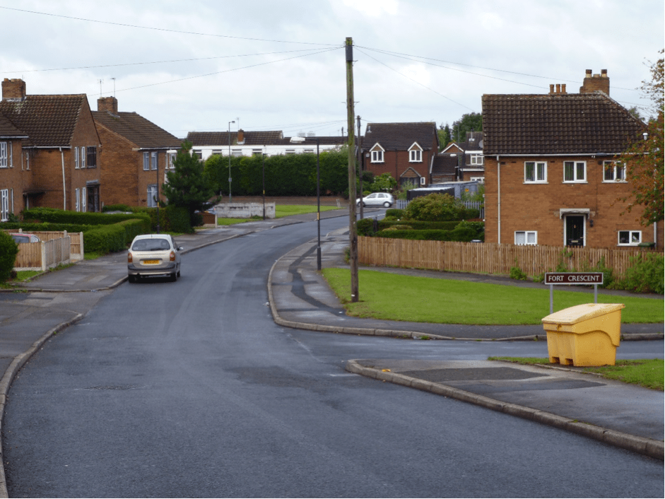
Image kindly supplied by David Evans.
There seems to be pattern, and a line developing. In nearby Beacon Way, just off Salters Road, there is the same sudden gradient in the roadway.
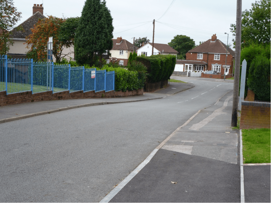
Image taken by David Evans.
(I took note of this, and pulled it up in Google Maps. David is quite correct, there is a clear line in the physical geography of development. – Bob)

Imagery from Google Maps clearly shows a line through the Castlefort/Holly Bank estate. Please click for a larger version.
To complete my exploration, I went to where Holly Lane and Lichfield Road once met – where the Shire Oak tree stood. The footpath in Lichfield Road here shows signs of a sudden gradient, over which the road has been later re-profiled.
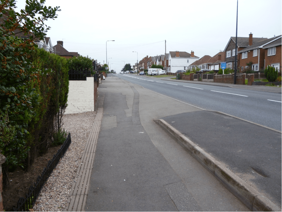
Image by David Evans.
From here, the ridge appears to run over the old school fields (partially now the site of a modern housing estate) and along Commonside. I did not walk that section of what may be the Vigo fault. I know that the school sports fields were re-profiled to provide the sports pitches, and this has given a marked bank in the slope there, which could be misleading.
(Intrigued by this observation, I resorted to Google Streetview. This is very interesting. If one follows Commonside northwards from Friezland Lane, The houses on the left – east side – are clearly higher than those on the right; also, the school field slopes down here to the road in a very marked way. – Bob)
But, somewhere along here was an area known in the oldest days of Walsall Wood was ‘The Cape’. I wonder if this referred to some drop in the surface many years ago, and possibly well before the local coalmining began. Is ‘Cape’ perhaps a derivation of another word?
David Evans, September 2013
 RSS - Posts


I lived in Fort Crescent from 1954 until I got married in 1970.Most of the houses in the Crescent were affected by the subsidence but as we were at the top of the road and away from the fault, we only had cracks in our walls. I remember the houses that were demolished and some of the people that lived there.
You could follow the fault from Castle Rd right over to and across Lichfield Rd where, in those early days, there was a significant drop in the road just above Streets corner.
Dave (Eddy) Edwards
If you look at the Aldridge end of the Vigo fault, namely the very bottom of Leighswood Avenue. Look at the London Planes, If you look up from Leighswood Road, they lean to the right while those from about a third of the way up are up right. Plus in the 18 years I’ve lived in this area, there has been a constant issue with broken drains and mains at the bottom end of Leighswood Avenue. Leaning mature trees normally indicate ground movement.
HI Bob
many thanks for cobbling my notes together in to this excellent presentation, and for Peter’s super photos, too.
kind regards
David
.
David and Bob thanks. I live very close to the Vigo and am fascinated by the information David has uncovered and the time and trouble he has gone to in researching the area of “The Vigo” Thanks David.
The route that Bob has highlighted in red I probably walk every day with the dog, but I hadn’t fully appreciated the significance of walking in virtually a straight line from Beacon Way to Castle Road over what is “wasteground”. Where New Wood Grove now sits was an old club which whilst being set back from the road surely didn’t stretch all the way up to Druids Walk did it? It seems a heck of a distance, or was it the car park or something? Did the club eventually close because it had had its day or was it closed due to subsidence?
Any of the more mature gentlemen (old!) shed any light on it?
Would be great to hear any stories of the club opposite what is now Little Nicks the gents barbers.
Thanks again to everyone on this one…………
Peter
The club referred to was the Walsall Wood Labour Club, created by Mr ‘Johnny’ Poxon who was also the secretary. His name is commemorated in a nearby road. The club was built on the extreme edge of the common, which ran between the Brickmaker’s Arms and the club. Both
were originally built on common land, as enclosures, with the common at the rear extending up to Holly Lane. The Brickmakers Arms had a garden at the rear, but the Labour Club had no such facility, just a little boundary fence just behind the club. A modest little plot, actually.
There was a frontage to the club, but as cars were beyond the means of most Labour Club members, no real provision was made for them.
The club was a single-storey building, with provision for a live-in steward, I think the first appointed was a Mrs. Bostock. Popular little club, but I never remember any ambitious plans for building extensions or any improvements. Some months ago, on the blog, there was a photo of a Rifle Club, taken in the club, featuring some of the members.
The club was still there in the Fifties, when I left the Wood, but all the surrounding development going on, could have affected its future. I cannot remember any subsidence in Salters Road. At the time, the only visible subsidence I remember was in the Lindon Road area.
There is an apparent fault on the Walsall Wood road,Aldridge.I was told this by an ex miner a good few years ago and it a noticeable drop in the road surface.If you travel up the road it is somewhere around the section between Walton Rd and Glendower Rd.Bit sketchy as i don’t travel that way any more.
We lived in Fort Crescent at the rear of the Labour Club in my younger days. Both my father ( Bill Edwards) & my grandfather (Elija Merrick) were members of the club. We visited many weekends, saw entertainers and had cockels or mussels from the travelling salesman. Each year we would go on the club trip to the seaside and each child would be given a 10 shilling note in a brown envelope. There was a pathway at the side of the club which led through to our road. We would go this way to school and also to the local grocery shop,( Smiths ) in Salters Rd which supplied all our needs even delivering the groceries each Friday in a cardboard box.
The land at the rear of the club remained common for many years and we played there as children building dens and catching lizards and frogs etc. There was often a travelling fair that would set up on the sight.
Halcion days of childhood.
Dave Eddy Edwards
Does nobody remember the time when a huge hole appeared across the Lichfield Road ( A461), opposite where Holly Lane was ? It could have been in the late 1960’s or 1970’s ……but I’ll stand corrected if someone knows better.
I was returning home from work in Walsall ( by bus, I didn’t drive then) when the Lichfield bus was stopped and told to turn left down Brownhills Road. The reason for this, was the most amazing ‘hole’ which had appeared across the main Lichfield Road going up Shire Oak Hill. It was just past Streets Corner, opposite Holly Lane.
Going up the hill, I walked past what appeared to be a land slide, leaving a hole big enough to lose a double decker bus in, just like the one I had got off !
I shall never forget it.
I imagine this could also have been said by the people who lived in the houses by the hole.
This place is shown in the photograph taken by David Evans, where the pavement has rather a steep, strange slope down to the houses.
From reading the blog, it would seem to have happened along an extension of the line showing The Vigo Fault.
I will be interested to know if anybody remembers this, or has any further information about it.
Hi Jenny
From talking to people around at the time, it was apparently a collapsed sewer. David raised this question some weeks ago in an email to me.
It’s interesting science. If you have have lorries coming downhill to the lights, they’ll tend to brake as the slope intensifies. This pulls the road surface into a ‘hump’ over time, as they brake in the same spot. A similar effect can currently be seen in the road surface outside Barclays in Brownhills High Street, where there are four neat ruts where the busses come to a halt. As they become more exaggerated, they amplify as vehicles roll into them.
The road surface moving cracked and collapsed the sewer, which caved in, so I am told. A fractured large sewer does indeed look like a very big hole.
The last time the Lichfield Road was relaid, micro piles were applied – perpendicular steel ties under the surface – which stop the road surface moving so readily.
I’d like to caution folk here about the nature of the fault, to think about it. The fault contains the boundary of the coal seam; on the Walsall Wood side, it’s coal-marl geology, hence the Aldridge and Walsall Wood pits. North of the Vigo Fault, the geology is sandstone, mudstone, gravel and sand, hence the Sandhills and Shire Oak quarry – the soil either side is quite different. The Vigo Fault is where the two converge.
The fault didn’t occur because of mining. It’s not exacerbated by it, either; remember in previous articles we detailed the difficulty the Aldridge miners had in crossing the Vigo fault and that the attempt was abandoned after a year or so.
The faults here are a founding part of the bunter ridge that is Shire Oak; it’s what makes the area, and was absolutely set in stone many millennia ago. In that sense it’s static, a geological absolute. It isn’t dynamic, there will be no play or room for movement. I’ve heard it said that the fault suddenly dropped; had it done so, we’d have made national news.
Having said that, the loss of houses in the Castlefort Estate was nailed to subsidence caused by the Aldridge colliery, but remember, these houses were probably built straddling or on the ‘coal’ side of the fault, so movement may have occurred locally causing the problem. The distance we’re taking here in not yards, not feet, but less than an inch to destabilise a house.
http://brownhillsbob.com/2012/02/04/sink-estate/
Be mindful that there is a tendency for folklore and miner’s bar-rom tales to exaggerate subsidence; think of the houses by the Black Cock. People are very attached to tales of extreme subsidence, but they rarely occur in the manner we imagine them to. Very often this is amplified by journalism that doesn’t, by nature, understand the issue enough to call it out.
http://brownhillsbob.com/2011/07/09/the-way-the-land-lies/
There’s also the issue of sink holes, which is what caused the canal breach around 1982 near Catshill, also oft attributed to mining, but not apparently the case.
http://brownhillsbob.com/2012/04/20/under-mined/
Hope this helps a bit – I have been researching it a little since the subject came up.
Cheers
Bob
Thank you Bob,
It’s good to know what caused it after all these years.
Jenny
Hi
It’s what I’m told. It’s a hole, and I’m still looking into it 😉
I will be dredging the newspaper archives to see what I can find.
Cheers
Bob
All sorts of things ican produce incredibly large holes in the road: Sewer collapses, water main bursts, electricity cables failing, and a main sewer is a pretty substantial hole, supported by Victorian brickwork. The subsidence myths just abound, the great sinking house one being the most common.
Pingback: The wind blew up the Watling Street | BrownhillsBob's Brownhills Blog
Pingback: The water, of course! | BrownhillsBob's Brownhills Blog
Pingback: Early days in Foxes Row | BrownhillsBob's Brownhills Blog
If you follow the line further along from the commonside photo, would this lead to Cape Close which is on the ‘other’ commonside which runs behind Pauls Coppice? Could this be related to the Cape query I wonder?
Walsall Local History centre published a book in 1994 called “Coal Mining in Walsall Wood, Brownhills and Aldridge.” On page 4 of the said book, there is an annotated map which shows where the Clayhanger and Vigo faults are in relation to modern street in the area. The book is available to lend at Walsall libraries.
You may be interested to know that on page 57 to 60 there is information about Walsall Wood Colliery and subsidence in relation to the mining.
Sarah